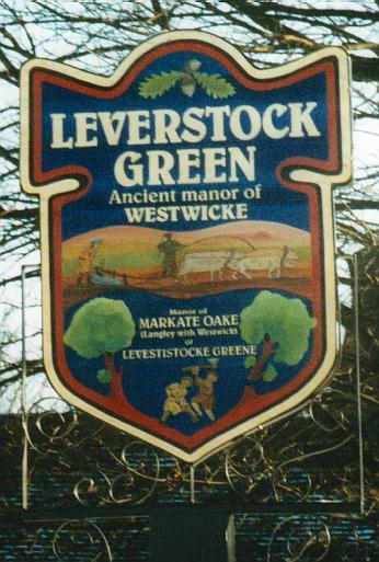
WESTWICK, is often refered to in early documents, parish registers etc. as a place in its own right, and indeed it was until LEVERSTOCK GREEN developed into a settlement in the 17th/18th centuries. Gradually over time Leverstock Green has incorporated the settlement along Westwick Row into itself, and now many local folk don't even know of its existance.! However, since the year 2000 our new Village Sign refers to the old Manor, so hopefully more will read it and want to find out more.
The term "the manor of Westwick" has two distinct meanings. One referring to the entire estate and lands under one overlord, and entitled to its own Courts Baron; the other referring to a manor in the sense of a good sized farm or dwelling house, and probably the principle holding in the estate. Very early manors (i.e. the dwelling) would have probably combined the office of farm and dwelling for the Lord of the Manor. Later manor-houses would have been purely dwellings for their Lords, a separate demense farm being a little distance from the manor-house.
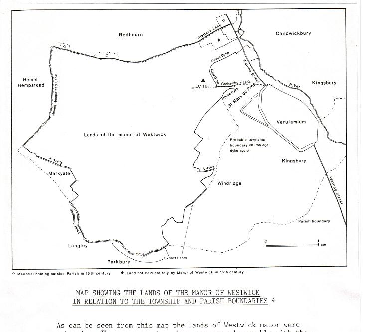
The manor of Westwick in the sense of a largish estate, had boundaries which have been relatively easy to define, and which are shown in the map, based on the map on p.101 of David Neal's report on settlement at Gorhambury. [S103,Fig. 117, p.101] It is also shown in Jonathan Hunn's report BAR 236.[S167,p.65] As can be seen much of the area of the lands of Westwick fell within the area of Leverstock Green within the parish of St. Michael.
In 19th century documents and earlier a person's place of residence was given as simply Westwick, meaning they lived within the manor. Most residents of Westwick would have lived in and around Westwick Row, i.e. in today's Leverstock Green, but others would have lived nearer to St. Albans. With the development of Hemel Hempstead New Town and the shifting of civil boundaries during the last century, Westwick Row and its immediate environs is divided between being in part within Dacorum Borough Council, and in part within the civil parish of St. Michaels, St. Albans. It was all within the ecclesiastical parish of Leverstock GReen when it was formed about 1850, and is now within the ecclesiastical team parish of Chambersbury and the district of Leverstock Green.
What is meant by the manor (house) of Westwick is much more difficult to define, and has almost certainly changed at different points in time. From the time Sir Nicholas Bacon built his Tudor mansion until the present century, the seat of power for the manor in its widest sense has been Gorhambury. ( So from 1563, the manor "house" of Westwick Manor could be said to have been Bacon's Gorhambury, and from 1777/1784 the present Gorhambury mansion. - Click here to see the page devoted to the connection between the Gorhambury Estate and Leverstock Green) Prior to then the waters are somewhat muddied, though with recent work dating the earliest part of Westwick Cottage back to the end of the 12th century/begining of the 13th, it is becoming a somewhat clearer.
EARLY OWNERSHIP OF THE MANOR OF WESTWICK
942-6 - The manor of Westwick was bequeathed by Aethelgifu to Queen Aelfgifu at about this time. [ VCH, Vol. 2 p.393 ]
996 - The manor of Westwick was granted by King Ethelred to the monastery of St. Albans. [ VCH, Vol. p.393 ] At the time of this granted it consisted of 8 "yokes" of land, a Kentish term for a quarter of a hied i.e. 30 acres. In hertfordshire this is usually referred to as a virgate. This means that the grant consisted of 240 acres, i.e. 2 hides. A hide was a taxable unit based on the amount of land suficient to sustain a single farming family, suggesting there were just two units in 966. [S300]
After 1077 - Abbot Paul of St. Albans, granted the manor of Westwick to Humbald, a kinsman of of his, Paul's, successor, Abbot Richard de Albini. This was done at the request of Archbishop Lefranc, and was only for life. Abbot Paul was Abbot at St. Albans from 1077 - 1093. [ VCH, Vol 2 p.393.]
1086 And The Domesday Survey. - Leverstock Green, Westwick, and Rectory Manor ( Chambersbury ) are not mentioned as Domesday settlements. However, that does not mean to say that there was necessarily no settlement within our area of study at this time.(In fact there are various pointers to suggest that there had been continuing settlement from Roman times.) Kings Langley, Abbots Langley, St. Albans, Redbourne and Hemel Hempstead are all listed in Domesday, and as their respective lands spread to and converged upon the area of study, settlement within the area would have come under the headings of one or more of the villages previously mentioned. This is because the entries related to manorial lands rather than nice tidy villages. In addition, by the time of the Domesday survey, the manor of Westwick was to all intents and purposes under the control of the monastery at St. Albans, providing income for the refectory. Westwick's returns would therefore have been included in those for the monastery as a whole.
1184-1219: Tree-ring annalysis showed Westwick Cottage to have originally been an isled hall house dating to this period -making WEstick Cottage one of the earliest known and continuously lived in properties in the country. Westwick Row itself therfore being provably in existance at this time. This was also confirmed by hedgerow dating along the Row. (See here for diagram of Westwick Cottages timbers (Scroll down from Whitby Hall) and details on the hedgerow annalysis which has been undertaken.)
THE DE GOREHAM FAMILY & WESTWICK For much of the earlier part of the middle ages it was the de Goreham family who owned and Lorded it over Westwick, and who were to later give thier name to manor so that it was to become Gorehambury, Westwick & Pre. For details of the family and their continuing connections with the Manor see here.
1248 - Land in Westwick was given to the house of St. Mary de Pre (a Benedictine nunnery founded by the Abbot of St. Albans in 1194 ) by Alexander, son of Richard de Langel.[ VCH p.400 ]
1272-4 - Many of the recorded medieval field names in the Manor date from this year and include Birnorth, Bradefielde, Bunscrofte, Bunslande, Dells, Deanes Elwernescrofte, Helders, Langforlonde, Layehill, Maneringe field ( the predecessor to Manyagfield), Stonerds, Whitewellbeche and Yongs. (See the Medieval Field Name map , for the location of many of these fields. [S167, p.256-266] In addition it is inferred that the farmstead at Stonerds can be dated back to this time, making it one of the earliest farmsteads established in our area of study, and being in the heart of modern Leverstock Green, in its position off what we now call Green Lane. [S167, S192]
1290 Lay Subsidy Rolls showed 29 tax payers in the Manor. [Read this sometime in May 2000, now cannot locate the source! Possibly Jonathan Hunn.]
Documentary evidence from the 14th century concerning Westwick is apparently condradictive. A survey undertaken in 1306, when John de Gorham possessed Westwick ( to see entry for the 14th century click here) gives a valuation of the estate both in capital terms and acreage as considerably higher than the Inquisition Post Mortem carried out in 1327/8.(See entry for that year.) The rental values of the messuages are so widely apart that Jonathun Hunn considers that the manor settled upon John de Gorham and his wife Isabella in 1307 could not have been the same property as that surveyed in 1306. An even greater discrepancy occurs between these earlier surveys and the figures for the manor of Westwick upon its reversion to St. Albans Abbey in 1395. (See entry for that year.) [ S103, pp102 - 103.]
In addition to the various documents mentioned above, HALS (the Hertfordshire Record Office) has many documents concerning land and property transfer which refer either ambiguously to "the manor of Westwick" or to just "in Westwick". This latter could refer either to the manor as a whole, or the "village" (vill) of Westwick. It is therefore impossible on many occasions to be sure which relate to fields and property within the area of study for the Leverstock Green Chronicle, and those which are outside it.
In addition to this, there was during the middle ages, a very definite "vill" or township of Westwick, which contrary to earlier theories, now seems to have been centred on and spreading out from Westwick Row. It is difficult to know if this vill spread as far as Gorhambury, or if the medieval dwellings discovered at Gorhambury merely amounted to farmsteads. A further medieval "manor" was discovered built over the site of the Roman Villa at Gorhambury. [ CAR ref.4084, grid reference 1175 0793] Pottery found on this site having been dated to the 13th century. Further evidence of a medieval farmstead CAR ref. 6807 at 1175 0795 supports the idea of the now shrunken medieval village, with the fullest extent of the village and its related farmsteads spreading from Westwick Row to Gorhambury; but post Black Death, the vill shrunk back to just the area around Westwick Row, leaving isolated farmsteads at Gorhambury and Hill End.
In February 1489/90, Master William Waryn bequeathed " to my wife Emma the farm of Gorhambury and all the lands and tenements which I hold by copy of court roll or charter." [S232,203] In a previous will, that of Alice Harryes, written on 7th September 1485 ( see entry for that date), Alice referred to herself as the "relict of Hanry Harryes of Gorhams". The "village" of Westwick almost certainly also incorporated the many dwellings around Westwick Row, and to my mind the above mentioned wills suggest that the village was probably around the Rowe, with just a manor and farmstead of Gorhambury being further to the east at the CAR site 6807. Hillend was obviously considered part of the settlement at Westwick as evidence in another will dated 23rd August 1487.(To see entry for that date click here.) I am also of the opinion that there were not two, but three or possibly evenas many as five candidates for the manor (house) of Westwick in the Middle Ages, two of which come within present day Leverstock Green.
The first is what was thought to be the medieval "manor" at Gorhambury,near the present day great house, and traces of which were uncovered during the excavations at Gorhambury.[CAR ref 0062] The second is the site mentioned above dated to the 13th century, CAR 4084, and in more or less the same position as the Roman Villaat Gorhambury. These are the sites which until recently have been preferred by the archaeologists as the site of the manor of Westwick.. There was undoubtedly a substantial dwelling on the villa site in the 13th century. [S216; S103; S167]
The third possible site of the manor is Westwick Row Farm, which until the end of the last century was known as either Westwick Farm or just Westwick. It's name in old documents as just Westwick, ( and occasionally even Westwick manor), coupled with the fact that the original medieval open hall was some 33.5 feet long, "an inexplicable length for a house of this social level," as stated in a letter from the Royal Commission on Historical Monuments to Mr. Dennis Bell-Taylor of Westwick Row Farm in 1978, makes it a distinct possibility. [S127]
The fourth, though possibly least likely, (but favoured by archaeologist Christopher Currie) was a house which by the survey of 1569 was the demense farm or "home farm" for the manor, and which was situated off Westwick Row near to where Westwick Warren is today. The house itself was possibly demolished by the early 17th century, although the 1768 survey shows a dwelling of some kind on the site. It was known to have had in the field opposite to it a Great Tithe Barn, which was demolished in 1633 [C.R.O. IL28-IL31; IL33; IA68; D/EV/P2 ]. [See earlier section on the Middle Ages, specifically The Great Tithe Barn of Westwick.]
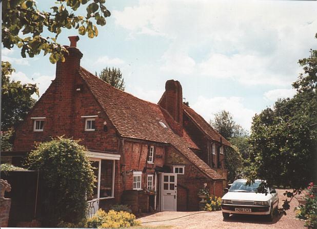
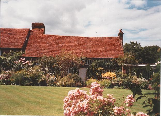
However, the site now generally held to have been the Manor House of Westwick, at least in the early Medieval era, is Westwick Cottage. Considerable evidence exists to show that Westwick Cottage was a high status Aisled Hall House which can be securely dated back to the end of the 12th century and begining of the 13th century. English Heritage acept it as being one of the earliest continuously lived in houses in the country. ( Click here for more information.- Scroll down from Whitby Hall) Dendrochronology has dated some of the timbers to between 1184 and 1219, and other evidence is also highly suggestive of a very high status building from the end of the 12th century with marked similarities to work found in Peterborough, Wells, Worcester, Lincoln and Salisbury Cathedrals at this time, and at a time when Abbot Warin of St. Albans was felling wood locally for the Priory at Pre and had "set up a form of timber-merchants office in which he did a brisk trade..." [ Report by Alan Greening on Westwick Cottage, 1997]
What now seems most likely is that the messuage considered to be the Manor House varied over the years, moving from Westwick Cottgae, to Westwick Row Farm, possibly to the house near to the present day Westwick Warren and then to the various sites at Gorhambury. Unless someone invents a time machine that really works we shall probably never know for certain. Fashions change, and people aren't always satisfied with an extension in order to bring their home up to date! A new dwelling, more modern in style is therefore built not far away. The original house is unlikely to have been demolished, but used perhaps as a dower house, or to provide accommodation for an estate official. Possibly it was at this point that the two names Gorhambury and Westwick became necessary.
Time moved on, the manor house for the gentry became a farm, and another, again more modern house was built along Westwick Row, perhaps at Westwick Row Farm - hence the unusual length for the hall.
Further along Westwick Row the demense farm to the manor was built. Because of its importance, the tithe barn was built next to it. Probably by this time the manor had reverted to the control of St. Albans Abbey, with the Abbey's Steward being installed in one of the manors or farms, and a tenant in another? It may also at one time have been considered the principle manor of the estate, especially if this was at a time when the Abbey was in control of the estate. By the time Sir Ralph Rowlatt was granted the estate at the dissolution in 1540/41, he may have decided to make Gorhambury the seat of the manor, leaving the demense farm in Westwick Row to a tenant - (Henry Knight by 1569). By this time Westwick Row farm had already been given as copyhold property elsewhere, and the manor at the villa site had probably fallen completely into disrepair. Ownership of the Westwick Cottage building having gone into Freehold and allowing the continuing alteration and development of the property.
All this is of course supposition, but it does account for the apparent importance of the properties in Westwick Row, and the equally apparent discrepancies and contradictions in the surviving documents from the period.
All this uncertainty does also leads to complications when trying to chronicle the history of the area, as properly if the site of the manor was within Gorhambury park, then it was outside our area of study; if on the other hand it was any of the other candidates, then it was within our area of study. To make things even more difficult, some documents can be easily attributed to a particular property, whereas others merely refer to either "lands in Westwick" or a "messuage at Westwick". Unless I can definitely conclude that a transaction was OUTSIDE our area of study, I have included it in the Chronicle, as on balance it seems more likely to have fallen within the area around Westwick Row, and therefore to be within our area.