11th CENTURY
1073 -1559 - Hertfordshire was transferred to the Diocese of Lincoln, but the area under the jurisdiction of St. Albans Abbey ( The Liberty of St. Albans ) remained autonomous. That part of Leverstock Green in the parishes of Abbots Langley and St. Michaels would have been under the control of the Abbey at St. Albans, that part in the parish of Hemel Hempstead, in the Diocese of Lincoln. [ S88 ] From the 11th century until the 12th century, Cashio Hundred was known as the hundred of St. Albans. [ S167, p.67]
After 1077 - Abbot Paul of St. Albans, granted the manor of Westwick to Humbald, a kinsman of of his, Paul's, successor, Abbot Richard de Albini. This was done at the request of Archbishop Lefranc, and was only for life. Abbot Paul was Abbot at St. Albans from 1077 - 1093. [ VCH, Vol 2 p.393.]
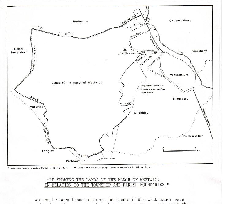
1086 And The Domesday Survey. - Leverstock Green, Westwick, and Rectory Manor (Chambersbury ) are not mentioned as Domesday settlements. However, that does not mean to say that there was necessarily no settlement within our area of study at this time.(In fact there are various pointers to suggest that there had been continuing settlement from Roman times.) Kings Langley, Abbots Langley, St. Albans, Redbourne and Hemel Hempstead are all listed in Domesday, and as their respective lands spread to and converged upon the area of study, settlement within the area would have come under the headings of one or more of the villages previously mentioned. This is because the entries related to manorial lands rather than nice tidy villages. In addition, by the time of the Domesday survey, the manor of Westwick was to all intents and purposes under the control of the monastery at St. Albans, providing income for the refectory. Westwick's returns would therefore have been included in those for the monastery as a whole.
Late 11th Century. Habitations in most parts of England in the late 11th century followed a very ancient pattern of isolated farms, hamlets and tiny villages, interspersed with fields, and scattered over most of the cultivatable land. Woodland accounted for only about 15% of the land. It was not until Tudor times that most of the villages in the south of the country became more nucleated and developed individual identities. In Hertfordshire the pattern of isolated farmsteads well dispersed throughout the county, continued well into the eighteenth century, even though small market towns such as Hemel and Berkhamsted were becoming more prominent. [ S74 ]
In the same way that Domesday referred just to "manors", many documents from the later middle ages until as late as the early twentieth century, referred either to manors or to parishes. This is largely because the system of law and government was based upon manorial holdings during feudal times, and parishes from Tudor times. It was the local "vestry" that was responsible for implementing the Poor Law. If someone was referred to as having come from a particular place, it generally referred to the parish in which they lived rather than the centre of that village or town. Therefore a person, or grant of land being in say Abbots Langley, (either the medieval manor, or the roughly similar pre-nineteenth century parish), could just as easily refer to North End Farm or Carpenters Farm (at the most northerly end of the old Abbots Langley parish) as to the land surrounding the "village" and the church of Abbots Langley, three miles distant. [S74 ] It was only really after the development of the relatively modern postal system, that addresses as we know them today came into being. This differing perspective between the twentieth century and the eleventh, makes extracting relevant information from ancient documents difficult, as there would at first sight appear to be no references made to the immediate area.
Settlements in the western Chiltern districts of Hertfordshire in the 11th century, were most common in the river valleys, and where there was a plentiful supply of woodland for timber and keeping pigs. Although Leverstock Green is on a ridge of higher ground, evidence suggests that especially in the northerly half of our study area, it supported good woodland, which was later cleared for cultivation. Blackwater Wood, still in existence today, is purported to be the remnants of a 12th century wood or forest. As mentioned previously, the "stock" part of the name Leverstock Green probably refers to a tree stump or clearing in a wood. [ S74 ]
THE 12th CENTURY
Abbot Geoffrey de Gorham (he was Abbot of St. Albans from 1119 - 1146 ) built a hall at Westwick for the use of one of his friends, (unnamed in the original documents), who was also a benefactor of the church and a relative of some sort. It is thought the person for whom he built the hall was Hugh, son of the Humbald to which the manor had originally been granted in the previous century. Hugh was Geoffrey's brother in law, and the manor was granted to him ( Without the consent of the convent, though it belonged to the monk's refectory, who used the revenue from the land to help supply the refectory.), on the occasion of his marriage with Geoffrey's sister. Hugh appears to have taken the name " de Gorham ". [S9,Vol.2,p.393 ]
Peter Newcome in his "History of the Abbey of St. Albans" states that:
"Then all the lands of Westwick, which had been granted to Humball for his life, and which at first had been set apart for the use of the monk's table, he granted to the son of Humbald, who had married a sister of Geoffrey. He granted also some lands, near Westwick to a familiar friend and client, who had been born of obscure origin at a small hamlet in Normandy, called Gorham, and this he confirmed by charter."
As the above quotation refers to two separate grants of land, is this then why later we have both Westwick and Gorhambury given as separate manors or villages/hamlets? Westwick itself being in the vicinity of Westwick Row, and the place of the Gorhams at Gorhambury.
1135 - 1153 - England was torn by civil war between King Stephen and his cousin Matilda ( sometimes known as the Empress Maude ), and not settled until the Treaty of Wallingford in 1153 when Matilda's son Henry of Anjou was declared heir to the throne upon Stephen's death. The general anarchy which spread throughout the country, probably accounted for the fact that Abbot Geoffrey de Gorham was able to grant land without proper permission.[ S69 ] (N.B. To those of you who have read The Brother Cadfael Chronicles by Ellis Peters, or who watched the Cadfael series on television, this is the period represented. Historically both books and T.V. series painted a very accurate picture of life at this time. )
1151 - 1166 - During these years Abbot Robert de Gorham was Abbot of St. Albans, and he confirmed the grant of the manor of Westwick which his predecessor had illegally conferred upon Hugh " de Gorham". [S9.Vol.2 p.393 ]
1163 - Henry II declared the Liberty of St. Albans exempt from episcopal visitation and all forms of episcopal control. The Liberty, or Archdeaconry, of St. Albans covered 26 parishes, including St. Michaels, and Abbots Langley. It therefore effected all that part of our study area which fell within the Liberty and the Hundred of Casio. [CRO VIII B 60; S232,p.v]
1166 - Another Geoffrey de Gorham ( presumably Hugh's grandson and Ivo's son), held the manor of Westwick from the Abbot of St. Albans. For this he paid suit at the hundred of Cashio every three weeks, and gave two-thirds of a knights fee. [ VCH, Vol.2 p.393 ] A knights fee was land held by a tenant with an obligation to provide military assistance to his lord when requested. The total holdings of knights fee's owed to the lord, was the total number of knights the tenant should muster, plus these knights' various villeins, if the lord should call upon them for military service. [ S70, glossary.]
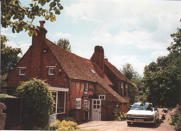
1184-1219 - This is the date given to the timbers of the original part of Westwick Cottage as a result of dendochronological testing undertaken in 1997, and confirmed by Adrian Gibson a known expert on old timber framed buildings. The quality of the timbers is particularly good, making it very rare in Hertfordshire, and even nationally. The house was originally an open hall house of high status, it's size and type of timber giving this information. [ S298,S300, S328]