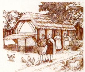
13TH CENTURY - general comments
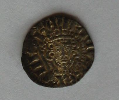
In the second half of the 20th century, a silver Henry III Long Cross penny was found in the rear garden of one of the houses along Leverstock Green Road, between Green Dell Way and Highland Drive. (See photos above.)The coin itself was undated, but Henry III reigned from 1216-1272, and long cross coins were minted during his reign from 1247. Although the coin need not necessarily have been dropped during this period, it is unlikely to have been dropped very much later, and is additional proof that the route was in continual use from Roman times.
Silver pennies had been minted from the 8th century and for 500 years were the only coin struck in England. The Saxon penny weighed 22.5 grains, and there were 240 pennies to the Saxon pound weight of silver. Hence the original pre-decimalisation currency had 240d to £1. In the 10th century a long cross began to be put on the reverse of the coin so that it could be broken accurately into half-pennies and farthings. It was not until 1279 that groats(4d), half-pennies and farthings were issued. A silver penny at this time was worth a great deal and could purchase a lot. In Ellis Peter's novel The Heratic's Apprentice, set in Shrewsbury in 1143, 570 silver pennies (£2 7s 6d) was the amount found in a casket and considered a considerable dowry for Fortunata; it also stated that she had never seen more than a few silver pennies in her entire life, as the foster daughter of a merchant. Although the silver penny found locally was a century older than the pennies in Miss Peter's novel, there is nothing to suggest that the relative value of money and coinage had actually changed much in a century. However the EH website suggests a present day purchasing value of £3.07 for a 1d dated 1264.
In 1180 a new series of pennies were minted with a short cross on the reverse, but from 1247 more longcross pennies were minted with the ends of the cross reaching the edge of the coin in order to deter clipping. The longcross penny found off Leverstock Green Road showed signs of having been clipped for it's silver. Despite it's very great age, the coin is very beautiful, and Henry's face and crown can be clearly seen. [Owner of the coin; S93, p197]
The hallmote ( that is the manorial court,) of the manor of Kingsbury was held sometimes at Childwick (presumably at Childwick Bury or Childwick Hall between St. Albans and Harpenden,) and sometimes at Westwick. Court rolls pertaining to the manor between 1216 and 1327 are preserved among the manuscripts of the Earl of Verulam, and are now at HALS (the Hertfordshire Record Office. .[ VCH p.400 , S 39. ]
Thirteenth Century records of the parish of Hemel Hempstead show names in the area of WESTWICK CROSS, THE TYLEKILL and LASTOCKINGE. [ VCH Vol 2 p.216] According to a map showing the holdings of Margaret Wootton,[ S1 p.30 ], Westwick Cross is where Westwick Row meets Green Lane ( There is a staggered cross-roads still there, joining Green Lane, Buncefield Lane and Westwick Row.)
In all probability The Tylkill referred to a tile kiln at or near to Tylkiln (or Tile Kiln), the name of the farm or dwelling which had originally stood at the far end of Tile Kiln Lane. Although other kiln sites were possible within the parish of St. Mary's Hemel, it almost certainly referred to that previously mentioned, as other documents have retained the name at the same site from the 16th century through to the present day. In particular, a survey undertaken of the manor of Hemel in 1650 referred to Elkana Settle paying a quit-rent for lands at Tyle Kilne and later that century documents referring to Leverstock Green Farm (Carpenters Farm) quote land abutting to the farm as belonging to an Elland Settle. Assuming the TyleKill to have referred to the same site as Tyle Kilne or Tile Kilne Farm, then it suggests that the manufacture of tiles in this area took place as early as the 13th century, and possibly even earlier.
Lastockinge sounds to me as if it may have been an early form of Leverstock Green. In Jonathan Hunn's map of the medieval field names in Westwick, an area within the parish of St. Michael's is shown, called La Stokkyng. Although this field is nearer to Kettlewells than the area which later became known as Leverstock Green. However, Medieval field names are frequently used in more than one field in an area, especially as they usually refer either to the nature of the ground, or its development or it's one time owner. In the case of la - stocc - ing it could mean the (la) tree stump (stocc), place (ing) or possibly the home of someone called Stocc or Stokk or even Lestock. In anycase I think it is reasonable to assume that Lastockinge referred to somewhere in the region of present day Leverstock Green. [VCH II p.216; HRO 14397,80745; S167,p.265]
13TH CENTURY - chronological entries
1212 - Henry de Gorham ( Geoffrey's successor ) held land from the Abbott of St. Albans for payment of two-thirds of a knights fee. This land was presumably the manor of Westwick, and constituted four and a half hides. A hide was a unit of land, usually four virgates and notionally 120 acres in Hertfordshire.( A hide was mainly used as a unit for fiscal purposes.) If Westwick was 4.5 hides, then it must have been about 540 acres in extent. A fair holding, and roughly the same size as the land farmed today as Westwick Row Farm [ VCH, Vol 2 p.393; S70, glossary; S54]
1230 - Sir William de Gorham died, holder of the manor of Westwick. He was the son of the Henry mentioned in 1212. William married Cecilia de Sanford who was appointed governess to Eleanor, sister of Henry III. (Princess Eleanor, on the advice of Celia de Sanford took a vow of chastity after she became a widow at the age of 15. Later following a papal dispensation, Nell married Simon de Montfort, Earl of Leicester) He was succeeded by his son, another William de Gorham. Cecilia, William's widow, also took a vow of chastity at her husband's death. She was a very pious woman and was eventually buried in St. Albans Abbey. (see entry for 1251. If as seems now highly likely, Sir William and his wife Celia lived when not at court at their manor of Westwick, this would have been along Westwick Row at the present Westwick Cottage. This seems particularly likely given that Dame Celia was later herself buried at St. Albans Abbey.[ VCH Vol 2. p.393; S329 ]
1235 1263 - This was the time of the abbacy of John of Hertford. Abbey accounts during this time show that Geoffrey de Goreham held a knight's fee of 6 hides of which he had 4 hides, with one smaller tenant. [S300]
1248 - Land in Westwick was given to the house of St. Mary de Pre (a Benedictine nunnery founded by the Abbot of St. Albans in 1194 ) by Alexander, son of Richard de Langel. [VCH p.400 ]
December 13th 1250 - Matthew Paris the chronicler, writing from the Monastery in St. Albans, records a considerable earthquake in the area:
" On the day of St. Lucia, about the third hour of the day, an earthquake occurred at St. Albans and the adjacent districts......where from time immemorial no such event had ever been seen or heard of ; for the land there is solid and chalky, not hollow or watery, nor near the sea; wherefore such an occurrence was unusual and unnatural, and more to be wondered at. This earthquake, if it had been as destructive in it's effects as it was unusual and wonderful, would have shaken all buildings to pieces; it came on with a trembling motion, and attended by a sound as it were dreadful subterranean thunder. A remarkable circumstance took place during the earthquake, which was this: the pigeons, jackdaws, sparrows and other birds which were perched on the houses and the branches of trees were seized with fright, as though a hawk was hovering over them. and suddenly expanding their wings, took to flight, as if they were mad, and flew backwards and forwards in confusion, but after the trembling motion of the earth and the rumbling noise had ceased, they returned to their usual nests."
Earthquakes are not so very uncommon in this country as might be supposed, indeed Matthew Paris himself recorded three between 1248 and 1250, one of which was of considerable note to the members of the court of King Henry in London. Undoubtedly this particular quake would have been felt in the Leverstock Green area, being so close to St. Albans. [S170, p.190. see also entry for April 22nd 1884; S329]
1251 - Celia de Sanford, widow of Sir William de Gorham and governess and later lady in waiting to Princess Eleanor, died "Universally regretted". She was buried "with much honour" in front of the Altar of St. Andrew in St. Albans Abbey. [VCH Vol II p.393; S329]
1269. - This is the first written record we have of Robert Beneyet, who gave his name to Bennett's End. The name itself meaning the district or part of the parish occupied by Beneyet. [S1 p.9 & 281 ] The seventeenth century successor to the original Beneyet farmstead is still standing next to the "Bennett's End Roundabout" on the dual carriageway, and is the home of St. Nicholas' Nursery. It has over the years been known as Bennett's End House and Bennett's End Farm. Click here to learn more about the history of the farm.
1270. -The first documented settlement at Buncefield was recorded in this year. The field itself being recorded the previous year as belonging to Peter Bunne. [S1 p.9 & 281 ] The Bunne family over the next five centuries were important landowners and farmers throughout the area.
1272-4 - Many of the recorded medieval field names in the area date from this year and include Birnorth, Bradefielde, Bunscrofte, Bunslande, Dells, Deanes Elwernescrofte, Helders, Langforlonde, Layehill, Maneringe field ( the predecessor to Manyagfield), Stonerds, Whitewellbeche and Yongs. (See the Medieval Field Name map , for the location of many of these fields. [S167, p.256-266] In addition it is inferred that the farmstead at Stonerds can be dated back to this time, making it one of the earliest farmsteads established in our area of study, and being in the heart of modern Leverstock Green, in its position off what we now call Green Lane. [S167, S192]
1278 - William de Gorham died , seised of ( i.e. owning or holding ) half of the manor of Westwick. ( Quite what happened to the other half is unclear. There are so many different references to various parcels of land in Westwick, its impossible to say whether they were all part of the original manor, or whether some parts of Westwick were held by others anyway. For a while I've found it a little confusing as to who left what part of Westwick to whom, but by 1329,I think I'm right in saying it was all together. I have therefore left out who succeeded whom, as it is really only a family tree.) [VCH, Vol 2 p. 393/4 ]
1278 - Joan, daughter of John Howeles, granted land and wood in Westwick to the nuns of St. Mary de Pre. [VCH p.400 ]
1290 Lay Subsidy Rolls showed 29 tax payers. [Read this sometime in May 2000, now cannot locate the source! Possibly Jonathan Hunn.]