14th CENTURY.~ General comments
As with the previous century, there are some fairly extensive manorial records, in particular copies of court rolls etc. surviving particularly for the manors of Gorhambury & Westwick, Market Oak, and Hemel Hempstead, which if I had the time and sufficient scholarship could add considerably to our early knowledge of the district. Unfortunately most of what survives from these very early times is in Latin and in almost indecipherable scripts. I therefore rely for most of my information either on the published works of others, or on the brief descriptions of documents contained in the catalogues at the County Record Office. Unfortunately the latter is not always sufficient to enable me to determine whether or not the documentation is relevant to the study of the Leverstock Green area.
As with other centuries, I shall give generalised information first, and specifically dated entries afterwards.
During the fourteenth and fifteenth centuries, the various Abbots of St.Albans had exercised their rights of Lordship over the Liberty of St. Albans with extreme vigour. In particular they had punished with the utmost severity anyone who hunted in the immense warrens reserved for the use of the monastery. As the greater part of the area of our study was within the domain of the various Abbots, then it would seem highly likely that those who lived in this area, and therefore came under the rule of these powerful Abbots, would have suffered under the extremely harsh treatment meeted out to them. One Abbot, Thomas de la Mare, was particularly powerful and spent much of his efforts in increasing the authority and rights of the Abbey. It was this Abbot, who was the centre of the Peasants Revolt in St. Albans. [ S70 ]
1300 - The Population in England reached its peak at the turn of the century, and was not to return to such high levels again for 400 years or more. (See graph in November 1995 issue.) It is therefore quite likely that the population of the area of the Leverstock Green Chronicle may have reached 500 or more at this time. [S71, p13]
1306 - The earliest documentary evidence for Westwick manor was a survey carried out in 1306 for John de Gorham which described the Manor at Westwick.[B. Lib. Ms Cotton Tib E VI fol 236 v; S167 p.62.] The manor house comprised:
" a hall with chambers; a chapel with a certain chamber; a storied edifice beyond the gate with a chamber. A kitchen, a bakehouse, a dairy, a larder with a certain chamber, a granary with a chamber for the bailiff, a dwelling for the servants of the manor, two cow houses, two sheep houses, a pig-sty and gardens".
There was also a second messuage called Newbury which had a dovecote, and which was valued about the same. The valuation for the Manor was 40s; for Newberry Messuage 33s 4d; the rents and customary dues were £27 6s 7d; pleas and perquisites were 40s; fishing rights 2s; 13 acres of meadow were valued at 52s; 35 acres of wood at 8s 9d and 54 acres of pasture at 54s. The record for the acreage of arable has been damaged, but the total area was about 822 acres valued at £24 12s. The sum total being at least £63.[S103 p.102] The survey also gives a list of all the arable fields, pasture, meadow and woods with their acreage and value. (See separate appendix, copy in L.G. Library.) [ S167, p.62 and p.94]
1314. - The first documented settlement at Woodwells was recorded in this year. [S1 p.9 ] It was probably the home of Roger de Wodewell. [S23]
1317 -1319 - These years saw the culmination throughout the country of a series of calamitous harvests and famines, which caused unprecedented mortality. Although in Hertfordshire the greatest problems were felt in the north of the county, the area in the vicinity of St. Albans (and therefore in our area) also suffered. [S71, p.13]
1327-8 - An Inquisition Post Mortem was taken after the death of Alphonsus de Vere, of Westwick Manor. This showed that Westwick was held in fee of the Abbot and Convent of St. Albans by the service of 2 parts of a knight's fee and suit at the Hundred Court of the Abbot every three weeks. (That is, the tenant of the Manor was obliged to attend the court under the jurisdiction of St. Albans Abbey every three weeks.) The capital messuage (i.e. the principal large property of the Manor) was worth about 6s 8d per annum; rents and customary dues were £8 11s 4d; pleas and perquisites of the court 2s per annum; 4 acres of poor and dry meadow 3s per annum; 22 acres of wood of which the underwood (i.e. the young coppiced trees and brushwood, such as hazel and alder which were harvested before they reached maturity, and used for fuel, wattling and hurdles), was valued at 2s per annum and 305 acres of arable worth 50s 10d per annum. In addition the service of 6 "customers" (customary tenants), each holding half a virgate (i.e about 20 acres) worth 26s 8d per annum, at Christmas 20 hens worth 2/6d; 10 cocks worth worth 10d, at Easter 100 eggs worth 4d, at the feast of St. Michaels a quarter of oats worth 16d and one clove - a total value of £13 8s 10d.
The above valuation is rather different to that of the 1306 survey, and is in any case on a different basis, probably because the 1306 figures express the total valuation, and these figures which give an annual valuation. There are other discrepancies, so that David Neal concludes that the holding of John de Gorham of 1306 was not the same as that which was settled on the de Vere's in 1307. [S103 p.102-103] This further reinforces the idea that Westwick and Gorhambury were not necessarily synonymous even at this early time, and the shift in the focus of settlement from the Gorhambury area to along Westwick Row could well have begun as early as this. For more information on the Manor of Westwick click here.
1329 -1330 - Free warren in his manor of Westwick was granted to John, the seventh Earl of Oxford. This John had inherited Westwick from his father Alphonsus, who had been willed the estate by John de Gorham. To have free warren meant that all the game on the estate was his by right,and he could hunt deer, rabbit etc. If free warren was not granted to the holder of a manor, then only the king, and the bailiff's he appointed, had the right to hunt game. Poaching was a capital offence.[VCH Vol 2, p.394]
1334 - The Hertfordshire assessment for the tax of tenths and fifteenths in this year, assessed the manor/village of Westwick with the moderate quota of £2 13s.6 and a half pence. This assessment, together with other evidence led the author of the book "Deserted Medieval Villages of Hertfordshire" to class Westwick as a shrunken (rather than totally deserted) medieval village.
There was quite an arc of deserted or shrunken villages surrounding St. Albans, another of which was Windridge, which at the time of Domesday had 10 heads of household. It also appeared in the assessments mentioned above. [S71 ]
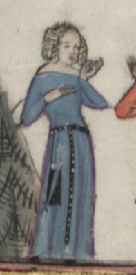
1335 - The Rector of the college of Bonnehommes monks at Ashridge (who had been given a great deal of land in the manor of Hemel Hempstead,by Edmund Duke of Cornwall in 1283/6), granted a Caructe (i.e. about 120 acres ) of land to Margaret Wooton and her husband Robert Albyn. This land was largely within our boundary and included Woodwells. (See the map in March edition of Ch. News showing the holdings of Margaret Wooton.) The lands held by Margaret Wooton and her husband were unusually consolidated, and covered some 150 acres. One possible reason for the consolidation of this holding, was the fact that they lay within an area which had ( in the 14th century) been recently cleared woodland, and the assart existed as a large undivided close. The Albyn family were very influential, and there is a brass to Robert and his wife in St. Mary's Church Hemel. (See copy of engraving reproduced from The History of Hemel Hempstead, [S1, p.31] and with the permission of Dacorum Borough Council.) This is possibly the only "picture" we have of people who lived in or near to Leverstock Green so long ago. Margaret was to live to a good age, dying in 1390. She outlived her husband Robert. [S1 p.31; S26 ]
1348-1349 - This was the era of the Black Death which affected the whole of the county causing substantial population decline. Many people who survived abandoned their homes and gravitated to the surrounding prosperous centres such as St. Albans. Although there is no direct evidence to show whether or not this happened in the manor of Leverstock Green,and the surrounding area of our study, it seems highly probable that this may have occurred to some extent. Even if farmsteads weren't abandoned, we can safely assume that the plague caused a toll on those who lived here, as in 1349 it is recorded that the manor of Abbots Langley lost eighty-two tenants. How many of those came within the area we now think of as Leverstock Green is unsure. [S10 , chapter 5]
1349 - A Royal ordinance, (called The Statute of Labourers 1349) sought to control wages at the level they had been on 1346, that is before the Black Death. (It was the first of several such Statutes in 1349,1351,1357, and 1360, each of which in turn attempted to fix wages and prices - the first real attempt to control inflation!) The Statute laid down that workmen were to receive wages at the normal rate of pay - i.e. 2d a day. This was "because a great part of the people, and especially of workmen and servants, had lately died of the petulance, many seeing the necessity of masters and great scarcity of servants, will not serve unless they may receive excessive wages."
Workmen breaking the Statute were liable to imprisonment; and masters paying more than the recognised rates were to be fined. The effect of this and subsequent legislation on the population, such as it was, of the area around Leverstock Green, is difficult to assess. The feudal system was already starting to decay, and many lords employed hired labourers rather than relying on villein labour. How matters stood in this area at the time I do not know, however it was this initial piece of legislation, as a direct consequence of the Black Death, which in turn, along with other factors such as poor harvests, high food prices and the imposition of the Poll Tax in 1377 which directly led to the increasingly rapid decay of feudalism, and the Peasants Revolt of 1381; this inturn meant that the kind of life led by the people of Leverstock Green would change as they became "free" men. [S70, S69]
1355 - Evidence suggests that inhabitants of part of what we now think of as Leverstock Green were obliged to have their corn ground at Nash Mills, and were also responsible for the many repairs to the mill: A court was held under the great Ash tree in St. Albans and a ruling was given concerning the mill at " Assemille" ( Nash Mills ) and its repair. The ruling - part of which is given below - mentioned various tenants within the parish of Abbots Langley, referring especially to those of "Northend". There is little doubt that these tenants would have lived in the northern end of the parish, and which would have included Chambersbury (or Rectory manor), and the area which became Northend Farm. (In the early part of the 20th century, the land belonging to Northen Farm was a narrow strip stretching from Leverstock Green Road - where the green is today - down almost to Nash Mills, and a little narrower than the distance between Peascroft Road and Chambersbury Lane.)
Northend was given its name as it was at the most northerly end of Abbots Langley, and was shown on maps as just "Northend" as early as the 17th century. Descriptions of the farmhouse as it was when it was demolished in the 1960s suggest it dated back to the 16th or 17th centuries, and was probably built on the site of an earlier dwelling. This, together with the proximately of Northend to Nash Mills makes it certain that the tenants of Northend mentioned in the ruling ( a translation of which follows ) were people living in part of what is now Leverstock Green. It is also worth noting that at this time Assemille was farmed out to a John de Chilterne who undertook to pay the Abbot rent, and would make what profit he could from the local inhabitants. As he failed to pay any rent, it seems likely that despite the tenants being obliged to have their corn ground at the mill, they either didn't pay him, or else failed to pay him enough.
"All villein tenants of Northend are accustomed 2(*) to carry the timber
by water, whenever the mill or the flood gates want repair, though not
for the mill house; and all the tenants of Northend, whether majors or
minors, mud the mill pond and repair any damage to the mill pond
whenever necessary. They also ought to build up, at their own expense.
and without allowance of other works, all the earth works round the
mill and the flood gates." 3
1359-60 - Breakspears was mentioned in a court roll dated xxxiii Edward terci (3rd). [HRO XI2]
January 1362 - There was a tremendous seven day storm which caused immense destruction throughout the south of the country, and which no doubt would have had a considerable impact on our area. [ S71 ]
1371 - Thomas, the 8th Earl of Oxford died, settling the manor of Westwick on his wife Maud. Maud held the manor of Westwick for life, with reversion to the crown on her death. The countess was unable to will the manor to her son Robert, as he was firstly heaped with honours by Richard II, and later ( in 1387) convicted as a traitor, after which all his lands became forfeit. [ VCH Vol.2 p.394.]
1371 - A new tax was introduced to help pay for the Hundred Years War with France - The Poll Tax. This was a levy of one groat (i.e. 4d) for each person of either sex over the age of fourteen: paupers and mendicant friars were exempted; beneficed clergy were to pay three groats. Similar taxes were later imposed in 1377 & 1381, the latter being a levy of one shilling per head on persons over 15 years of age. I do not know if those few who lived within our area paid these taxes, or like many others around the country, evaded them. Everything in history always comes full circle!! [S70; S69; S202]
1380 - Plague had again descended on the area, killing many inhabitants of the various hamlets in the parishes of Hemel, St Michaels and Abbots Langley. On top of the death toll of 30 years previous, many of the oldest of the farming folk were dead, and with them knowledge of the exact manor/parish boundaries. The lords of the manors therefore called the remaining inhabitants together, and with a jury of tenants walked the boundaries, taking evidence from reliable witnesses as to the exact boundary markings. "Beating the Bounds" in this way was the only way in which boundary limitations could be passed from one generation to another. It was traditional for stone crosses to be set up to mark certain limits, and it seems highly probable that "Westwick Cross" was traditionally one of the boundary crosses marking the division between Hemel Hempstead and St. Michaels.
The boundary of Hemel Hempstead at this time ran roughly down Green Lane,and along the line of what is Crofts Path today, and can been seen most clearly in the 1843 tithe map, as until that time it remained unchanged. It is pleasant to conjure up a picture of the folk of Hemel Hempstead walking along these lanes over 500 years ago, and to think we could more or less walk the same route along modern roads and pavements today. [ S78, p.64; S79,p.21.]
1381 - The Peasants Revolt. We know that at least one man from Westwick was involved in the revolt, and the rising against the Abbot of St.Albans for he received a charter. (This is effect pardoned his revolt, and granted him certain rights.) In addition there were disturbances at Westwick, and these men also received a charter, which like all the others was later rescinded. (It is uncertain whether this refered to the area around Westwick Row, or whether it woulf have been closer in to Gorhambury.) In any case it seems likely that someone living within the area of Leverstock Green would have been involved when so much was happening so close at hand; and at the very least it would have been of some importance to them. Abbots Langley is also recorded as having had trouble at this time. (It should be remembered that Abbots Langley included Chambersbury, Northend and land later to become Carpenters Farm (Leverstock Green Farm).[ S32 p244; VCH vol.4 p.201.
1384 - This is the earliest mention I have come across so far of manorial lands belonging to the priory of Markyate, and which became known as the MANOR OF LEVERSTOCK ALIAS MARKATE (or Market) OAK OR MARKET DOLE. In this instance John ate Raggs and his wife granted all their lands in Westwick late of the Prioress of Markyate to John Bunne and his wife. [C.R.O. 1 N 1] ( See entry for 1541/2 )
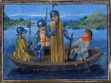
1387 - Robert de Vere, 9th Earl of Oxford, Duke of Ireland and son of Thomas de Vere, from who he had inherited the Manor of Westwick on his father's death in 1371, was heavily involved in the Battle of Radcot Bridge near Oxford.
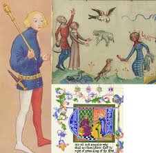
RIGHT:
Robert de Vere, Duke of Ireland, fleeing Radcot Bridge, 1387,
taken from the Gruthuse manuscript of Froissart's Chroniques (circa 1475)
THE MANOR OF LEVERSTOCK GREEN ALIAS MARKET OAK OR MARKET DOLE.
"The manor of Leverlestocke, Market Oak, Market Dole,( or Langley with Westwick.) was part of the possession of the priory of Markyate. The site of this manor is probably at Leverstock Green." [ VCH Vol 2. p.400 ] ( The map of early medieval settlement in "The History of Hemel Hempstead" (S1, Fig.1 opp. p.8), shows it as Lewest Stock Grene.)
Is it possible to be more precise as to where the above manor held by the priory was? David Neal's map of the Lands of the Manor of Westwick [S103, p.101], shows the area of land held by the Priory at Markyate to be the wedge of land roughly bounded by the Leverstock Green/Hemel Hempstead Road, and Bedmond Road,, excluding the field later known as Harps ( roughly where the Plymouth Bretheren have built their new meeting house, and where Westwick House and Westwick Nursery used to be off Blackwater Lane), running along the central section of Blackwater Lane, and taking in the crossroads formed by Bunkers Lane, Blackwater Lane and Bedmond Road, and some of the land immediately to the south-east of Blackwater Lane. The north-westerly end of this area, was at the parish boundary, that is roughly where Leverstock Green Farm stands, although as far as I can tell Leverstock Green farm was not part of this small manor, as later 19th century documents show it to be part of the mannor of Abbots Langley, and the manor of Market Oak etc. had been joined with the manors of Gorhambury, Westwick etc. in the 17th century..
In the log books of Leverstock Green School, an entry for 1863 and another for 1864 refer to Market Oak. It was obviously reconed to be closed to the village, as the school mistress and some children " ran for 15 minutes to Market Oak". However, Miss Purvis's school run, and the Market Oak refered to by Sydney Dollimore in his map were refering not to a mano, but to a specific oak tree. This tree was shown on the Gorhambury estate map drawn up in 1768 [HRO, D/EV/P2] as being on the highway from Leverstock Green to Watford, i.e the road we now know as the Bedmond Road. The map shows its possition as being directly in line with the then field boundaries of Great Coles and Further Market Lands. Its position is perhaps the best evidence we have for the aproxamate whereabouts of the manor house which may have been near to this tree.
In the 1930's the area along the Bedmond Road, on either side of the road, between Chambersbury and Bunkers Lane was known to some as Market Oak,and the remains of some kind of dwelling,overgrown with grass at the corner of Bedmond Road and Bunkers Lane was generally thought to have be Market Oak Farm. [S112, S113]
~~~~~~~~~~~~~
1390 - Margaret Wooton, widow of Robert Albyn, and a principal landowner in the area to the NW of Green Lane, died. In her will she directed that she should be buried near her husband in the parish church (St. Mary's Hemel), and added:
"Lego tantum argentum quantum possible sit emere mihi et marito meo Roberto Albyn unum lapidem marmorium ad cooperiendum corpora nostra."
The will contained no geneological details, but it seems unlikely that Margaret and Robert had any children to inherit, as a William Brantyngham was the residual legatee. [S26]
1395 - Abbot Thomas of St. Albans bought the reversion of the manor of Westwick, from Maude, Dowager Countess of Oxford, for a sum in excess of 800 marks. (A mark was 13s 8d.) Part of this money was subscribed by friends of the Abbot. The manor of Westwick was once more in the hands of the convent at St. Albans, who had always regreted the loss of the income it generated. (Partly in timber and game such as rabbits, but largely as a good arable farming area.) [VCH, Vol.2 p.394 ]
1399 - The property Megdells was mentioned in a court roll dated xxiii Richard II. [HRO XI2]