1500 - The property called Dixies in Westwick was conveyed to Thomas West of Tygheley by William Stepneth and John Marchall (schoolmaster) and others. I wonder how and when they got it from Robert Stodley, and why was it owned by several people? Also where was John Marchall a schoolmaster? The most likely place is at St.Albans Abbey. [VCH p.401 ]
30th March 1501 - All the land mentioned in the Gorhambury Survey of 1569 as being the copyhold property of Robert and Richard Lacebye, together with certain parcells of land then belonging to Thomas Peacock, i.e.. Blushes Crofte, Hagdells, Kittecrofte and certain lands in Shrewfeild, were mentioned in a court roll dated 30th March 16th Henry VII. [HALS XI2]
1523 - A manorial survey covering Hemel, Bovingdon and Flaunden (bearing in mind that the area covered would not have included the whole of our area of study,) showed that there were still unenclosed areas of open field. Two fields in particular were in our area. One was called "Woderedyng" and would appear to have covered a large area directly north of the village, beginning somewhere around the village centre and going up as far as Woodwells farm or further.( Part of this field can be seen in the map showing the holdings of Margaret Wooton, reproduced in the March 1996 edition on Chambersbury News.) [S1 p.30] The other was called Robyns, Pit and Peascroft and would appear to have covered the area bounded by today's Peascroft Road, Longfield, Tile Kiln Lane, and possibly as far up to Brickmakers Lane. The names Peascroft and Robyns (though spelt differently) are still present in this area, and the Pit probably referred to a clay pit. [S1 p.12-13.]
1527 - The lands of the priory of St. Mary de Pre - which included various scattered parcels of land around the Leverstock Green area- (see 1248 and 1278), were granted to Cardinal Wolsey, who gave them to his foundation called Cardinals College at Oxford. [VCH p.400 ] They had previously been annexed by the Abbey of St. Albans by Papal bull, but Wolsey obtained another bull to give them to his college.[ VCH Vol. 2, p.401 ]
1529 - Cardinals College Oxford was dissolved upon Wolsey's disgrace, and the manor of Pre and all its holdings, was leased for 30 years to Richard Raynshawe, a yeoman of the guard. (This included lands and woods at Westwick - see entry for 1527 ) [ VCH Vol. 2, p.400 ]
1531 - Henry Bestney sold to William Sharpe land called Tyghel, Dykes and Bushcroft. Henry Bestney had previously bought them from Thomas West. (see 1500 ). One of these properties may or may not have been the property previously known as Dixies. [ VCH Vol. 2, p.401 ] Bushcroft was probably in the area of what is now Beechtree Lane.
1532 - All the possessions of the nunnery at St. Mary de Pre were granted by Henry VIII to the Abbey of St Albans, in 1531. The Abbot then leased the property to Richard Raynshawe, who already held some of the land from Cardinals College.. (This included land at Westwick, see previous entries.) [ VCH Vol. 2, p.400 ]
1533/34 - From a court roll dated xxv Henry VIII, it would appear that Edmond Carpenter and his wife took over the copyhold of Breakspears : "a messuage with a Curtilage and lx acre of lande." [HALS XI 2]
1538/39 - We know from a court roll dated the thirtieth year of the reign of Henry VIII that John Feilde held the copyhold of the following parcells of land, all in the vicinity of Blackwater Wood: Little Brach, Great Brach, the close next to Great Brach, Pondfeild or Hyltons Laye, and Bullshott. [HALS XI2]
15th June ? 1539 - "John Feilde son of John Feild" and "Dyonysia Feilde" were both buried in St. Lawrence's Churchyard Abbots Langley. It is difficult to say whether these were perhaps twins, brother and sister or mother and son. This was one of many entries for the Feilde family, which judging from the baptismal names given to the eldest son (nearly always John, occasionally Richard or Benjamin) were the same Feilde family which held Blackwater farm and the Manor of Market Oak. [S99]
December 5th 1539 - THE DISSOLUTION OF THE ABBEY OF ST. ALBANS. - The manor of Leverlestocke etc. was included under the rent of the customary tenants in Westwick. [ VCH Vol..2 p.400 ] The manor of Westwick also reverted to the crown. [ VCH, Vol. 2, p.394 ] That is to say that both manors of Westwick & Leverstock Green (Market Oak) had been under the jurisdiction of the Abbey at St. Albans, and that at the dissolution, the Crown became the Lord of the Manors until such time as they were sold on by Henry VIII.
The Manors of Abbots Langley and Hemel Hempstead also reverted to the Crown upon the dissolution - Abbots Langley having been part of the lands belonging to the abbey at St. Albans, and Hemel being part of the lands of the BonnHommes at Ashridge.
The Manor of Chambersbury (or Rectory Manor ) had also reverted to the crown at the dissolution, and was later granted to William Ibgrave, the King's embroiderer. This manor had previously been one of the sub-manors within the Liberty of St.Albans. ( See entries for September 28th 1540, & 1556.)
1540 -The manor of Pre and its holdings again succeeded to the crown, and were granted to Ralph Rowlatt. On March 12th Henry VIII granted the manor of Westwick to Ralph Rowlatt. From then on these manors descended with Gorhambury. I shan't list the dates of each transfer of the lands involved through the generations, as this has already been done in the section on the Grimston's. [Chambersbury News, July and August 1994] In any case, for the most part, all that is necessary is to know that the manorial rights and much of the land (unless sold off separately, or held as Copyhold property) belonged in turn to the Rowlatt's, the Bacons and the Grimston family, later Earls of Verulam. [VCH, Vol. 2 p. 394 ]
September 28th 1540 - Following the dissolution of the monasteries, Henry VIII sold the manor of Abbots Langley to Richard Lee, a military engineer, but sold the patronage and the remaining revenues of the living of St.Lawrence (Abbots Langley's church), along with the manor of Chambersbury, to William Ibgrave, of the Hertfordshire Commission of the peace. He was also the King's embroiderer.
Chambersbury was also known as Rectory Manor because its revenues were associated with the Rectory of St. Lawrence Abbots Langley. The receipt for this sale was found in the 1940's among some old papers of Mrs. Reynolds Solly of Serge Hill, Abbots Langley, and reads as follows:
" This bille made xxviiith daye of Septembre in the xxxiind yere of the reigne of our sovereigne Lorde kynge Henry the VIIIth wytnesseth that I Edward North esquire treasurer of the revenues of the augmentacions of our sayd Sovereigne Lorde the kyngs crowne have receyved of William Ibgrave of Langley Abbott in the countie of Herts esqyre the some of two hundreth pounds sterlyng in full contentacion and paymente of the some of four hundreth and three score poundes tenne shyllyngs and tenne pence sterlyng beyng dew unto the kynges highnes for the gyfte grannte and purchas of the rectorye or personage called Abbotts Langley with his rights and appertenances in the countie of Herts latelye belongyng and appertayniyng to the late monasterye of Saynte Albans in the sayd countie of Herts nowe dyssolved and for an yerelye pencion of twentie shyllyngs yerely goyng oute of the vycarage of the Langleye to the sayd rectorye or personage and for the advowson of the vycarage of Langley aforsayd and for one pece of lane conteynyng by estymacion three acres lyeng and beyng in Abbots langley aforsayd and for a water mylne called Nasshe mylle beyng upon the sayd landes and for all water courses and ryvers appertaynyng to the same mylne and for all that cotage called mylne house with the appertenances in Abbots Langley aforsayd lately belongyng to the sayd late monasterye whiche sayd some of two hundreth pounds sterlyng shalbe dew unto the kyngs majeestie at the fyrst daye of Octobre nexte ensueng the date herof as by recognysaunce in that behalfe made more playnlye dothe and may appere In Wytnes whereof I have sealled and subscribed this bille with my hande the daye and yeare above wrytten."
[ S84, p.25 ]
It seems probable from various documents held at the County Records Office, that Samuel Reynolds Solly obtained the Lordship of the manor sometime between 1836 and 1839. It presumably remained with his family until the Law of Property Act in 1922 when copyhold tenure was abolished. A further document held at the Hertfordshire record office, and made at a much later date - (probably 18th century) gives much the same information as the above bill of sale, but in simpler terms:
"The King by his Letters Patents in Consideration of £460 10s 10d paid into the Treasury by William Ibgrave Esq. gives & grants to the said William:
The Rectory and Church of Langley Abbotts with all its rights & Appertenances lately belonging to the Monastry of St. Albans And all Messuage Houses Edifices Glebes Land tenements Meadows Pastures Comons Pensions Portions Tythes Oblations Profits Emoluments Rents & Servcies Whatsoever in Langley Abbotts or Elsewhere to the said Rectory belonging And all that the Annual Pension of twenty shillings payable by the vicar of Langley Abbotts to the said Rectory And also the Advowson and free disposition & Right of Patronage of the Vicarage of the Parish Church of Langley - One Piece of land contayning 3 acres in Langley Abbotts One Water Mill called Nashe Mille & all Waters Water courses & appertenances therunto belonging A cottage called the Mill house a Wood called Notely Wood & the soil therof A wood called Leavesdon Wood in the soil thereof in Caysho in the Parish of Watford And one grove of wood contayning 2 Acres & 14 acres of Wood in Abbotts Langley lying upon the Hill And all other woods to the said Rectory belonging. And also a Messuage Garden and piece of land therunto adjoyning in the Towne of St. Alban in the Malt Maket. In as full and ample Manoer as the last Abbot or his Predecessors before the Disolution of the Monastry had held & enjoyed the same. To hold to the said William Ibgrave his Heires & Assignes for Ever of the King his Heires & Successors by the service of the 20th part of a knights Fee & the yearly Rent of 51s 2d Sterling on the feast of St. Michael." [HALS 71528]
17th October 1542 - "William Ibgrave son of Robert Ibgrave of the city of London" was buried at St. Lawrence's Church Abbots Langley. It is not clear whether this is the same William Ibgrave who received the labnds from King Henry VIII in 1540, or perhaps his father. The latter is the most likely as evidence from other sources suggested that the King's embroiderer died in 1555. Although there is another burial of "Mr. Willeam Ibgrave Esquire" recorded in November 1555, together with an Inquisition Post Mortem, which Wiliam was which is unclear. .[S299]
1542/43 - Edmond Carpenter sold 23 acres of land (Pondfeilde) which had been part of the holding of Breakspears to Walter Hawgood. [HALS XI2]
7th December 1543 - " Magistra1 Elycia Ibgrave" was buried at St. Lawrence's Church Abbots Langley.[S299]
1543/44 - From a court roll dated the 35th year of the reign of Henry VIII, various parcells of land, including a messuage or tenement in Westwick Rowe, (possibly what is now known as Dell Cottage), were the copyhold property of one Giles Dell. This land was later inherited by his son Henry and his daughter's husband Edwarde Birchmore. (see entry for 1569) [ HALS XI2]
A messuage called Megdells and its lands were also mentioned in court rolls dated xxxv Henry VIII. [HALS XI2]
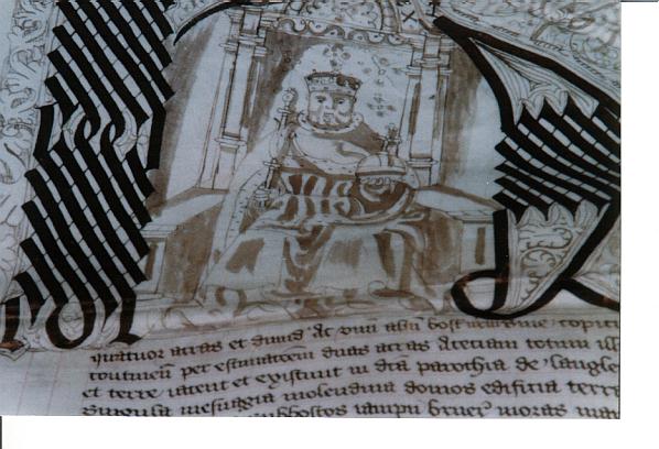
1544 - A survey of the Manor of Abbots Langley was drawn up for Henry VIII. The document is held today at the County Records Office [HALS 80911], and is in well written Latin. The initial letter of the document is delightfully illuminated with an unmistakable portrait of Henry VIII seated on the throne, holding the Orb and Sceptre. No doubt considerable useful information could be gleaned from this document concerning properties within the manor such as Northend and Leverstock Green Farm. Unfortunately, although the script is very clear, it is all in Latin, and as yet has not been translated. [HALS 80911]
1544/45 - Edmond Carpenter sold 15 acres of the land holding of Breakspears to Thomas Birchmore. [HALS XI2]
1545 - According to the Subsidy Roll, Westwick had 13 taxpayers at this time (therefore possibly a population of 60 -65) who were assessed as having to pay 4s 6d together. [ S71 ] It is interesting to note that Jonathan Hunn considered that there were 13 properties along Westwick Row at the time of the 1569 survey 24 years later. It is possible that there is a correlation between these properties and the Taxpayers as listed - thereby showing that the township of Westwick was considered to be just along Westwick Row. [S167, p.191]
William Ibgrave had obtained Hyde manor in 1545 (that is the lands and pastures to the north of Toms Lane, which had been seized from the manor of Abbots Langley in 1066); by now owning Hyde as well as Chambersbury, William Ibgrave had increased his holding and would seem likely that at this point the land between Bunkers Lane and Chambersbury Lane was also owned by William Ibgrave. [ VCH vol. p.326; S32 p.143; S 86 p.21 -22.] ( See entry for October 29th 1555.)
Late c.15th/early c.16th - Hill End Farmhouse was built as a 2-bay hall house. [ S32 ] (Mention was made of the messuage or property of Hillend in 1549.) [ HALS 1E6 ]
8th May 1549 - Nicholas Brystow esquire, granted to John Marston, Hill End Farm, along with 56 acres of land. The rent was 13s.5d. The Marston family were to be associated with Hill End and Stonehall until 1637 [GORHAM - 1E 6]
1st April 1550 - From letters patent of this date, the Archdeaconry of St. Albans was formally transferred to the Diocese of London. Therefore all the that part of our study area which fell within the parishes of Abbots Langley and St. Michaels were no longer in the Diocese of Lincoln, but in that of London. [S232,p.v]
28th July 1550 - Thomas Byrchmore inherited from his father Richard Byrchmore, 15 acres of land known as Noosefield in Westwick. This land is thought to have been somewhere in the region of Megdells and Breakspears. Probably where the motorway is now. [HALS IG3]
1551 -Leverstock Green was known as Leveleystocke grene ( Sidney Sussex College Documents.) - This is considered to be the earliest form of the name of our village known, according to the English Place Name Society. [S1 - p.283, S23 - p.13
October 29th 1555 - William Ibgrave, made his will while on his deathbed. This will, ( a full copy of which is in an appendix ) gave Chambersbury to his son Thomas:
"... Also I give and bequeathe my howse with all furnyture thereof and all my lands to Thomas Ibgrave my sonne and heire..........The Residue of my goodes, not given nor bequethed, my debts paide and my buriall discharged, I give wholly to Thomas my sonne and heire....." [ S86, p.21 ]
5th November 1555 - St. Lawrence's Church (Abbots Langley) recorded in its register that: "Mr. William Ibgrave Esquire was buried here." As he only made his will 7 days before, he presumably died in the intervening week. [S299]
1556 - An Inquisition Post Mortem for this year, on the property of the late William Ibgrave, showed that Chambersbury Manor had a capital messuage called Jurdens, which had been lately rebuilt, and was inhabited by William Ibgrave. Reading the section in Scott Hastie's book concerning Abbots House [S239, p.40], together with HALS document 37788 concerning Jordens in 1629 and the information in the Victoria County History,[ Vol.2, p.326], it seems quite possible to me that the oldest surviving part of Abbots House, near St. Lawrence's Church in Abbots Langley, was in fact the rebuilt principle dwelling of the manor of Chambersbury, named Jurdens by William Ibgrave after his mother Joan Jurdeyn.
To have had the most important dwelling of the manor, which was afterall used as a court during the time prior to the Dissolution, at the centre of the community and near to the church made sense, even though the principle farmland, with it's farmhouse (Chambersbury), which provided the income for the upkeep of the clergy was a few miles distant, and within the area of the parish which was later to be incorporated into Leverstock Green. [VCH, Vol.2, p.326; HALS 37788; HALS 71532;S239, p.40]
July 1557 - All the land listed as being the copyhold lands of Richard and Robert Lacebye in the Gorhambury Survey of 1569 were mentioned in a court roll dated the 3rd and 5th of Phillip and Mary. [HALS XI2]
1557/1558 - Property, including cottages along Westwick Row, was known to have been held by Giles Dell or his heirs, as a court roll dated the 4th and 5th years of the reign of Philip and Mary showed them to have paid homage for them at this time. For the extent of the property see the entry for the Landes of the Late Giles Dell in 1569. [HALS XI2]
1558/1559 - According to the survey of 1569, a court roll dated 1st Elizabeth showed that a herriot was paid for the various properties on either side of Pancake Lane belonging in 1569 to William Howe, and probably to Thomas Howes at this time ( See entry for 1490/91). It included the Tudor property then on the site of the present Westwick Farm. [HALS XI2]
1559 - The allegiance of the 22 parishes under the authority of St. Albans Abbey, (The Liberty of St. Albans), including Abbots Langley and St. Michaels, large parts of which fall within our area of study, was transferred to the Diocese of London. [S88]
29th April 1560 - "Mr. Ellis Ibgrave and Misstress Bonnett Chytherall were married" at St. Lawrence's Church Abbots Langley. Ellis presumably was one of the sons of the late William Ibgrave. [S299]
22nd May 1560 - Walter Byrchmore and his wife Ysabella surrendered 18 acres of land known as Bunesfield, to Thomas Byrchmore. (Probably his brother). This particular part of Bunesfield was within the Manor of Westwick and therefore on the St. Michael's side of the boundary. [ HALS IG3,IG5 ]
1561 - Nicholas Bacon acquired the manor of Gorhambury/Westwick. From this time on there is a great deal of documentation concerning the farms, properties and land in the area. It was also dating from this time that consolidation of the estate proper began , and the gradual acquisition of Copyhold properties by the Lord of the manor took place, so that by the eighteenth century the Lord of the manor was also the principle landowner of the district. 1567 - Earliest record of Little Coxpond Farmhouse, Leverstock Green Road. (Now a listed building. )
4th May 1561 - "Mr. Benjamin Ibgrave was baptised" at St. Lawrence's Church Abbots Langley.; this was perhaps the son of Ellis and Bonnet Ibgrave married just over a year previously. [S299]
5th July 1562 - "Mr. Benjamin Ibgrave son of Ellis Ibgrave was Christened" at St. Lawrence's Church Abbots Langley. [S299]
1563 - The Crabtree pub is thought to date back to at least this date. [Gazette /12/97]
22 August 1568 - "Abraham, sonne of John Longe of Bennetsend" was Baptised at St. Mary's Church Hemel Hempstead. [S294]
1569 - Westwick Row was known to have at least 13 dwellings and probably a four-bayed Tithe barn - see section under The Middle Ages on The Great Tithe Barn of Westwick; accompanying map; and subsequent entries for 1569.. [S167, p190-191; S188; S189; HALS XI2]]
20th May 1569 - A Survey was undertaken of the Manor of Gorhambury, Westwick and Prey for Sir Nicholas Bacon, by Hughe Mantell and Richard Bowsewell. It is the earliest written survey in English of the manor, and actually covered all the manors of which Nicholas Bacon was then Lord. The survey, which is written in an incredibly clear hand, is bound into one large volume and details minutely all the holdings within the manor, and whether they are part of the demesned estate or belonging to someone else either by freehold or copy hold. Within each manor the entries were listed according to the lands held by individuals, rather than geographically. Each entry stated the name of the piece of land etc. and which other plots bounded it to the north, south, east and west. This therefore gives us some extremely valuable information not only about who owned and farmed the various parcels of land, but also the relative positions of all the fields and holdings, as well as the individual field names. are, however, some problems concerning the survey which Jonathan Hunn pointed out in his report. [S167, p.101; HALS XI 2]
Firstly more than one field had the same name, leading to a certain amount of confusion. Secondly, sometimes fields had more than one name. Thirdly, the surveyor would appear to have not always been sure which fields surrounded the one in which he was standing, even though he could be certain what that was called. For example, when walking along the line of fields IJKL the surveyor knew he was standing in field J and that I was to the north and K to the south, but G and F could be mistaken, and sometimes B and F were confused. Nevertheless, the location of most of the fields can be plotted when compared with the later cartographic survey of 1768.
It was clear from the survey that the feudal system was almost extinct, and that the land was for the most part enclosed, if not totally hedged, and that the vast majority of the land was held either freehold or copyhold by quite a large number of individuals. ( This in contrast to the 18th & 19th centuries when the vast majority of the land within the manor of Gorhambury was owned by the Grimston family, and let to tenant farmers.) Several large open or common fields still existed, with individual strips belonging to different people. - Laydene, Shrewfield and common Woodreddings, were mentioned as being common fields, also Blackreddings which was between Westwick Row and the Berkhamsted Way.
The size of these various holdings varied considerably from less than 5 acres, to 546 acres. It is also worth noting that one person's holdings weren't necessarily all together in one conveniently neat unit, but that different parcels of land could be held by one individual in a variety of locations, rather like players in a game of Monopoly holding the title deeds to properties at different locations around the board, with sometime more than one player owning the properties blocked together under one colour. It would be possible to list all the various parcels of land, their various owners and the relative positions of them, where they come within our study area. To do this in entirety is, I feel unnecessary. I have, however, covered much of the survey in detail as it is one of the earliest such detailed accounts of our area. Should the reader wish to get a more overall picture they should refer to the original document at the Hertfordshire Record Office. Despite it's great age the survey is very easy to read.
The first part of the survey concerned the lands belonging to the manor estate, that is to Sir Nicholas Bacon himself. Of these the most important from our point of view was the home-farm, situated along Westwick Row, in much the same position as Westwick Warren today. This is the property referred to as The Old House in HALS document IL3. This farm and its lands were let to Henry Knight. The survey says the following:
" The farme and landes in the tenure of Henry Knight being demeaned of the saide mannor of Gorham and Westwick/lying without the park. THE FERME HOUSE AND HOME FEILDE The ferme house with the yardes Garden Orchard and one Close adjoyning to the same house called Homefielde abutting Eastward uppon a Close of Richarde Lacebury called Stonelett and Westward uppon The Way called Westwick Rowe and Northwarde uppon a lane called Hogdgill Lane and Southward upon a Close called Longe Dennefeilde parcell of the saide farme. "
On my map showing the late medieval infrastructure of the area, I have shown Hogdgill Lane as being yet another lane leading from Westwick Row, and not just another name for Hodges Lane, which ran next to Westwick Row farm, as assumed by Jonathan Hunn in his report. I have based this on several premises. If we assume that Hogdgill Wyck is the same parcel of land which later became known as Hodges Wick, the survey for Hogdgille Wycke (see below) suggests that Hogdgille Lane ran around three sides of it - if you look at the 1768 map, and indeed even the early edition O.S. maps, that implies that the field boundary shown running almost parallel to Hodges Lane and towards Gorhambury was infact a lane as shown on my infrastructure map.
There are therefore two possible assumptions we can make, either Hodges Lane began at Westwick Row, travelled towards Gorhambury, around Hodges Wick field and back down to Westwick Row, effectively going around three sides of a rectangle, or the surveyor got it wrong when assuming that it was all the same lane. In any case I do not think it possible that he could have assumed Hodges Lane bounded the homefarm to the north, as it was too far distant. The exact location of the farm being established beyond doubt by the map of 1634. ( Copies of tracings of the relevant section of the 1634 map, and an extract of the 1768 map showing field names are held in the file at Leverstock Green Library, and will be reproduced in Chambersbury News later against the relevant years.)
Other land let to Henry knight included Long Denne feilde and Younges Wicke, Netherdene; Upper Denefelde Wellfeilde; Blackwater Croft, Hogdgille Wycke and a piece of ground in Shrewefeilde. Longe Denne feilde and Younges Wicke were two large fields, probably close to the home farm and abutting to East on the park pale, to the west on Westwick Rowe, to the north on Upper Holm Feilde and a field of Lacebies called Stonelete, and to the south upon Richard Smythes orchard and a close called Connydell.
Wellfeilde was reported as:
"...abuttinge Eastwarde uppon the highe way aforesaid called Westwicke Rowe and Westward uppon Berkhampstead High Way and northewarde uppon a Close of William Westes called fower acres Close and Southwarde uppon a close of Richarde Smythes called Bechefeilde."
Wellfield retained it's name until the Tithe survey of 1840. ( see map extract showing Field Names around Westwick Row and Leverstock Green, 1769.)
Blackwater Croft, being the front part of the triangular Harps field where the new Plymouth Brethren Meeting House has been built was:
"...abuttying Eastward uppon the highwaye leadinge from St. Albans to Berkhamstead and Westwarde uppon a close of one John Deacons called Markeyate lande and northwards uppon a Close of the said Lacebies called the Harpe and southwarde uppon a Lane called Blackwater Lane."
Hogdgille Wycke abutted:
"Eastwarde uppon Hogdgill Lane aforesaide and Westward uppon the same Lane and northwarde uppon a close of Lacebies called Wheal pightell and southward upon Hodgill Lane aforesaid."
A greater proportion of the land of the manor was held either freehold or copyhold from Nicholas Bacon as Lord of the Manor, and were listed separately under the names of the various freeholders and copyholders. One such freeholder was George Marston who owned what we now called Hillend, and then called:
"Stonynges..sett lying and beying at Hillend."
This was different from his brother John Marston who had apparently inherited Stones Hall (now Hillend Cottages) from their father William Marston. The Marstons between them owned the largest holdings of land within the manor, although not all of it was within our area of study. As well as the freehold land held by members of the Marston family, considerable copyhold land was also held by them, much of it in the area to the East of Westwick Rowe/Bery Lane and also to the east of Blackwater Lane, taking in much of the land on
either side of Hagdells Lane.
Another freeholder within our area was Thomas Walke who had gained possession of various lands from his wife who had inherited them upon the death of her first husband William White. This land included Westcrofte:
"One Close of land lying at Westwicke Rowe... abutting Eastward on a felde called Grovefeld and Westward om a Waye leading from Saint Albons to Berkhamsted called Berkehamsted Way and Northward on a Lane called Twychell Lane and Southwarde uppon a close called Blackredding Crofte."
Some of the other lands belonging to Thomas Walke were also of great interest:
"One pece of ground lying in a Common Feild called Blackrudding abutting Eastward on a pece of ground in the same feild of one Benjamin Ibgrave and Westwarde on Berkhamsted Waye and northewarde on Blackruddinge Crofte and Southwarde on a grove and a close of land now Henry Dells called.........." (This was left infuriatingly blank, however this would be in the right possition for the land around Dell cottage)
He also owned another part of Blackrudding:
" abutting eastwarde on Plichell Lane and Westwarde on Blackrudding Crofte and northwarde on Grovefeild and southward on the saide parcell of ground there, the said Benjamin Ibgrave..... One other crofte of land there called.....abuttinge eastward on Westwick Rowe and Westward on Twychell Lane and northward on the same Twychell lane and Southward on Plichell Crofte aforesaid.."
Walke also owned fields called Nynyngs, Nottescrofte, Little Woodfielde, Comen Woodfeilde, Balmes Dell, Blakesfeilde and two parcells of land in Lay Dene, another large common field. All this property was north of Blakes Lane (later Blacks Lane) and included:
"The house Orchard and two little wicks abbuttinge Eastward on a close called Nynyngs and Westward on Westwick Rowe."
The freehold lands of Benjamyn Ibgrave (probably a younger son of William Ibgrave who had obtained Chambersbury from Henry VIII) included:
"One pece of Lande lying in a felde called Blackrudding abutting Eastwarde on a crofte of Henry Dells holden by Copie called The Crofte behind the house and westwarde on Whites Land in the same feld called Blackrudding and northwarde uppon Westwick Rowe and Southwarde uppon the said Whites Lande called Blackrudding."
Little Blackrudding was listed as:
"One crofte of land called Little Blackrudding abbuttinge Eastwarde on greate Blackrudding and Westward on a field called Grovefeild nowe William Ewers late Thomas Howes and Northwarde on great Blackruddings aforesaid and southward on Berkhampsted Way."
One freehold property listed in the survey was of particular interest. This belonged to Thomas Sare and was called Stonardes. The earliest date we have for this property was 1273, and in 1377 a field known as Sares Hatche was in the manor, possibly also associated with this very central part of what is now Leverstock Green, being just off Green Lane from the Leverstock Green Road. In 1569 Leverstock Green was just that, a green being associated with the Manor of Leverstock. The entry in the survey reads as follows:
" One close of lands called Stonardes with a watering place or ponde in it abutting Eastward on Laverstowe Grene and Westwarde on the waye leading to Berkhamsted Way from Westwicke Rowe and Northwarde on newe mille Croftes now William Ewers in the right of his wife and southwarde on Laverstow Green aforesaiyd."
Listed along with other parcels of freehold land belonging to Richarde Smith was:
"Peazefeilds belonging to the house of the said Richard Smith called Blackwater House holden of Markyate."
If I read the various entries aright, Blackwater House was where we would expect it to be, to the south of Blackwater Lane. The fields surrounding it - Peacock's Nynings, Blackwater pightle, Putreding Spring and Peazefeilde are all part of the manor of Gorhambury and Westwick, and yet the house is said to be holden of Markyate - that is the manor of Market Oak etc.It is interesting to note from this survey, as well as other old documents, that women appeared to have more rights than was common by the 19th century. Land quite often appeared to pass down through the female line, and widows especially, frequently applied to the Courts Baron for rights of tenure. However, once they remarried, their new husbands appeared to gain the rights to the property. In this survey, it would appear that not only did some widows appear to have rights of tenure in some instances, but that one woman- Heleyn Clerke - had the freehold of a parcell of land called Blakes feild. This was next to other parcells of land with the same name and to the north of Blakes Lane.
John Feilde, presumably the father or grandfather of the John Feild who was to become Lord of the Manor of Market Oak alias Leverstock Green during the following century, held copyhold land principally in the vicinity of Blackwater farm. One of his parcells of land called One Close next to Great Brach, appears to correspond with the field marked Little Hiltons on the 1768 survey. It's description ran as follows:
"One other close of lande nexte adjoining to the great brache aforesaide abutting Eastward uppon the same great brach and westward upon a close of land nowe............holden of Markyate and northward upponn the said blackwater grove and southwarde upon the said way leading to Watford."
Other lands held by Feilde were: Pondfeilde alias Hyltons Laye, Bullshott, Great Brach, Little Brach.
John Feilde's neighbour would appear to have been William West who held the copyhold of other lands, including Little and Great Pondfeilds and part of Shewfeilde. This latter was a common field just the Leverstock Green side of Hagdells Lane. These fields were between Blackwater Wood and Hagdell Lane. William West also let out:
"A Messuage or Tenement in the tenure of Richard Smythe with the yardes orchards and backsides situate and being in Westwicke Rowe."
His other property around Westwick Row included:
"The close next the house, a parcell of mainpightell, The Nether Closes and Fower Acre Close.... "with a Springe (wood) in it abuttinge eastwardes in the landes demeasnes in the tenure of Henry Knight and Westward on the same demeanes and northwarde on Westwick Rowe and Southward on Berkhamstead Way."
Richarde Smythe was another copyholder of property in and immediately around Westwick Row. This was in addition to the land he rented from William West. It included another property in Westwick Row itself:
"One messuage or tenement with the orchards, yard, carthouse, garden and backside situate and being in Westwicke Rowe aforesaid."
Other fields included Mainpightle, Berryfeilde, Bunescrofte, Kyttescrofte (this included a tofte,) and Bechefelde, all of which were in the vicinity of Bery Lane and Westwick Row, and leading up to Gorhambury Park. He was also the copyholder of a parcell of land in Shrowfield. It seems probable, that the tenement, wasn't directly on Westwick Row, but a little way off it towards Gorhambury, as in the section on Beryfeild it said:
" One other close of lande called Beryfeild withe a way leading thense to the said tenement abutting east upon a field late Bunne and afterwards the said Smithes and nowe the Lordes by exchange with the same Smith."
In addition, Henry Knight leased:
"a grove of wood lying at Westwicke near to Richard Smythes tenement";
This was listed as being part of the land within the park of Gorhambury - which at this time extended much further towards Leverstock Green than in later centuries, and giving the name Newpark to some of the fields.
Thomas Peacock was another copyholder, partly holding land around Hagdells Lane, but also holding land and a messuage in the vicinity of today's Corner Farm. The Peacock family were still important locally by the time Holy Trinity was built, and several early gravestones record various members of the Peacock family. The fields included in Thomas Peacock's holding were: Upper Pightle, Home Pightle, Hagdell Grove, Great Kittescroft, LitteleKittescroft, Blushes Crofte, Hagdeales, and two parcells of land in the common field called Shrowefield. Another field belonging to Thomas Peacock was Berryfeilde and Peazecrofte, and separate from the rest of his holdings being:
" eastwards uppon a Lane called Bunnes Lane and Westwarde uppon another lane leading from Woodend to St. Albans and northwards upon a close called middell Berry Feilde and Southwarde on a close of lande late Sares called Mynettes."
Middle Bery Feild and Little Bery Feild, were also in the same area and belonging to Peacock.
Another important copyholder was Richard Lasebye holding:
" A mesuage or Tenement with the Orchardes, yard and Backsides sett and being in Westwick Rowe within itself."
He held Great Rudding, Dellcrofte, White crofte, Deane Feild, and Wheate Pightell.
Still in the Lacebye family, this time held by Robert Lacebye, were certain parcells of land in Leydene, Nynnings and Hewells Herne (these latter near to
the "park pale"), Leycrofte:
"One other close of lande called Leycrofte and Stonelete abutting eastwarde on the lordes demeanes in the tenure of Henrye Knight and Westward on Hogdgill Lane, and northwarde on the landes sometimes Springoldes and nowe parcell of the Lordes demeanes and southwarde on the same late landes of Springoldes now demeanes as aforesaid."
He also held Little Ruddings:
"...abutting eastward on the landes of Richard Lacebye called Great Ruddings and Westwarde on Henry Dell's House and Land ( now known as Dell Cottage) called the Crofte behind the house and the grove there and northwarde on West Wicke Rowe and Southwarde on Berkhamstead Way."
Lacebye was in addition the holder of the important triangle of land known as The Harpe.
"One other close of lande called the harpe abbuttinge eastward on a crofte of the Lordes in the tenure of Henrye Knight called Blackwater Crofte and westward on Berkehampsted Way and southward on the ground of one Deacon holden of Markyate."
Robert Lacebye also held the following: Clerkes Crofte and Clareswick, Woodfeild, Mercrofte (or possibly Mecrofte) alias Allyscrofte, and Mercrofte.
Giles Dell had evidently once been an important copyholder, his land since his death being divided between his son Henry Dell, and his daughter, the wife of Edwarde Birchmore. The lands being roughly divided so that Henry Dell received aproxamately 33 acres, and Edwarde Birchmore, 36 acres. As part of their holdings, Henry and his brother-in-law had:
"Two messuages or tennements in Westwicke Rowe lying together with the orchard and yardes in the several tennures of Edwarde Birchmore and the said Henry Dell."
The present day Dell Cottage is in the right possition and would appear to have been the tenement in question. I am unclear as to whether there were in fact two detached properties, or a semi-detached building. I now feel sure that one of these two messuages was what we now call Westwick Cottage, and that the land surrounding two properties were adjacent to one another. This is why what we now know to have been a high status dwelling in the 12th century, apparantly didn't exist for th e1569 survey, and yet survived in tact to the present day!
Of his father's land, Henry Dell now held: The Croftes Behind the House, Netherhomefeild, Stocking Crofte, and two parcells of land in Laydene.
Edward Birchmore held the copy hold of the following, "in right of his wife": Upper Homefeild, Middlefeildes, Overfeilde and four parcells of land in Laydene. They also seemed to have a moety (that is a half share) of the Grove. The entries for Henry Dell and Edwarde Birchmore reveal yet another small lane - Stockingecrofte Lane, which was to the south of the parcell of land known as Stocking Crofte.
The copyholder of two small parcells of land next to Twichell Lane (Pancake Lane) was Raufe Longe. This land had previously belonged to Thomas Howes, who by 1569 was deceased, and had also at sometime been in the possession of Peter Griggs. These two fields were called Overfeilde amd Homefield. Both were bounded on the east by Twichell Lane and to the West by New Mill Crofte. Overfeilde reached down as far as the village, it being abutted to the south by "Laverstowe Green". Homefield was immediately to the north of Overfeild.
Another important copyholder at this time was William Ewer. It would appear that he had obtained considerable land holding right at the heart of what we now consider to be Leverstock Green, and stretching as far afield as Megdells. His descendants still held the land two hundred years later when the cartographic survey of the Gorhambury Estate [HALS D/EV/P2] showed Samuel Ewer to be the owner of a substantial acreage in the centre of Leverstock Green. Westwick Farm and its attached acreage, which formed much of this land, was not to be incorporated into the Grimston estates until the mid nineteenth century. The farmhouse was referred to as:
"A Messuage, late Howes. A messuage or tenement in Westwicke Rowe with the yardes, Orchardes and Backsides late the said William Howes, within itself."
Several fields came with the farmhouse. One was Denefeld - which stretched from the house along Westwick Row to Green Lane; another was Homefeilde, which was immediately behind the house. Other land belonging to William Ewer was to be found on the opposite side of Pancake Lane (then Twichell Lane) and included Plychell Crofte, a pightell behind the house, and Grovefeilde. This was listed as being:
"One other close of lande called Grovefeild with a little spring 2 in it abutting eastward on a Close of one Ibgrave's called Little Rudding and a Commen feild called Blackrudding and Westward on Twichell Lane and Northward on Plychell Crofte and southwarde on West Crofte."
Other lands owned by Ewer included Blakes Crofte, Smythes Acre, Little Brodefeilde, Bridlecrofte and " a pece of lande in the commen feilde called Laydene.".
William Ewer also held various copyhold lands as a result of his marriage. One such was a property on the opposite side of Westwick Row to Westwick Farm. viz:
" A messuage with outhouses, yardes and Backsides late Sares and now the said William Ewers in right of his wief without fees"
It is highly likely, by a comparison of the field names etc. that this messuage, and the lands subsequently mentioned, was what was later to be known as Lawrence Farm or Bottom House. (See entries for 6 June 1603, 19 February 1708 and 14 August 1835)
This had another cottage joining it called Netherhouse Close:
"One other tenement or cotage with yardes orcharde and close therunto adjoininge called Netherhouse Close abutting eastwards on Comon Woodfeild late Whites and abutting westwards on Westwick Rowe and northwards on Blakes Feilde and Southwards uppon Westwick Rowe aforesaid."
Other land obtained from his wife on their marriage included New Mill Croftes, which were three fields running down Green Lane towards Stonards, and covering much of the land occupied by Leverstock Green School today; Mynettes, which bordered the very top end of Green Lane and which today would have been part of the Buncefield Depot, (see Map of Medieval Field names); Nokefeilde, Ivrings (or possibly Lurings, it was difficult to decipher), Littell Blakefeilde, Hasell Dell and a pece of Laydene. All these fields were in the region of Breakspears and Megdells.
Breakspears itself was owned by Edmond Carpenter, who like William Ewer had obtained it through marriage. Along with the house of Breakspears were several fields in its vicinity: Durynges, Pondcrofte, Northfield and Peazcroftes, Furrows, Brodfeilde, Blakesfeilds, Long Furlonge, Snotbeche,and Marlecrofte. He also had three parcells of land in Laydene. The exact size of the holding was obviously in doubt as a memo stated that an inquiry had to be made into it.
Another long established property in the area was Megdells or Magdeales. This was the copyhold "ferme and landes of Walter Hawgood." Magdeales was listed as:
" a messuage or tenement with the orcharde and yards and a springe of wood thereunto next adjoining."
The following fields formed part of the holding: Nether Bunnsfeld, Middle Bunsfelde, Over Bunssfelde, Six Acre Crofte, the Close Beneath the House, Pondfeldes, Great Smythesfelde and Further Smythes Feilde. The fields for the most part were adjacent to one another and stretched over as far as Hangmans Croft (or Hanging Croft as it was referred then.) Hogg End Lane was referred to as Portdell Lane.
The copyhold lands of Thomas Hedge included Wardes (Kettlewells). [HALS XI 2]
7 November 1569 - "Grace, daughter of William Longe of Bennetsend" was Baptised at St. Mary's Church Hemel Hempstead. [S294]
Mid 16th Century - According to Jonathan Hunn, the following farm holdings were of the sizes given in the following list. [S167, p. 153] :
Breakspears: 83.3 acres
Hillend: 173.1 acres
Megdell: 59.1 acres
Wards: 56 acres
Westwick Corner (Corner Farm): 101.2 acres
Westwick Row Farm (present name, then known as just Westwick): 48.4 acres
17th April 1570 - "Christopher sonne of John Puddefat of Bennette End" was Baptised at St. Mary's Church Hemel Hempstead. The name Puddefat (or Puddephat) appears frequently in St. Mary's Church registers. Several members of the family are given as coming from Bennetts End, others from "the bottome", others from Two Waters, Lovetts End and from Piccotts End, also Greenend (near Chaulden). This is the earliest record specifying Bennetts End as a Puddephat residence, and the Puddephats were still the principle Yeoman family at Bennetts End in the 18th century. It is however, unclear as to whether or not they remained resident at Bennetts End throughout the two centuries, or whether they moved about, and it was other branches of the ever larger family which were registered elsewhere. In addition to the later Puddephats buried in St. Mary's Churchyard, a Jeremiah Puddephat was buried there in May 1749, named as being from "The Wood", Wood Farm was between Bennetts End Farm and Hemel, and not far from the Hospital. Before the development of Hemel this century, the two farms were virtual neighbours. [S294]
6th August 1570 - "John the sonne of William Younge of Hilend" was Baptised at St,. Mary's Church Hemel Hempstead. It is unclear whether this referred to Hillside (later South Hills, Boxmoor), or Hill Farm Leverstock Green, or Hillend (Gorhambury). Other entries in the register refer to occasional fathers from St. Albans. [S294]
10 January 1570/71 - "Joan daughter of Henrie Puddefate" possibly of Bennetts End was Baptised at St. Mary's Church Hemel Hempstead. [S294]
10th August 1571 - "George the sonne of Richard Puddefat of ........ende" was Baptised at St. Mary's Church Hemel Hempstead. [S294]
19th October 1571 - "Ralph sonne of William Younge of Bennetsend" was Baptised at St. Mary's Church Hemel Hempstead. [S294]
16th March 1574/5 - "Elizabeth Aberrie widdowe from Woodwells" was buried at St. Mary's Church Hemel Hempstead. [S294]
19th March 1574/5 - "Jesabell wife of Robert Aberrie" presumably also from Woodwells, was buried at St. Mary's Church Hemel Hempstead.[S294]
16th April 1581 - "Elizabeth daughter of Thomas Longe of Bennetsend" was Baptised at St. Mary's Church Hemel Hempstead. [S294]
4th April 1582 - "William Longe of Coxpond" was buried at St. Mary's Church Hemel Hempstead. [S294]
28th March 1587 - "Abigale the Bastarde daughter of Raphe Puddefat of Bennetts End" was Baptised at St. Mary's Church Hemel Hempstead. [S294]
17th May 1582 - "Ales the wife of John Puddephat of Bennette end" was buried at St. Mary's Church Hemel Hempstead. [S294]
16th January 1582/3 - "Thomas Batchelor of Woodwells" was buried at St. Mary's Church Hemel Hempstead. [S294]
20th July 1587 - Thomas Peacock who held Palmers, (Known as Three Cherry Trees Farm at the beginning of this century,) was dead. The property eventually passed to his grandson, another Thomas Peacock. [GORHAM Vol. II p.228 & 231.]
Late c.16th. - Westwick cottage was considerably enlarged at this time. The farmhouse at Corner Farm was also probably built at this time, it is also now a listed building [ S32 ]
A third bay was added to the house now called Hill End Farm.
[S32 ]
28th January 1588/9 -"Jesabell Puddefat of Bennetts end" was buried at St. Mary's Church Hemel Hempstead. [S294]
27th January 1589/90 - "Marke the sonne of John Puddefat of Bennetts end" was buried at St. Mary's Church Hemel Hempstead. [S294]
18th October 1590 - "Rebecca daughter of William Feilde of Bennetend" was Baptised at St. Mary's Church Hemel Hempstead. [S294]
31st October 1591 - "John the sonne of William Feilde of Bennetsend" - was Baptised at St. Mary's Church Hemel Hempstead.
5th December 1591 - "Avril daughter of William Longe of Bennetsend" was Baptised at St. Mary's Church Hemel Hempstead. [S294]
9th January 1591/2 - "Elizabeth daughter of Richard Aberrie of Woodwells" was buried at St. Mary's Church Hemel Hempstead. [S294]
19th September 1592 - Robert Hedge and Elizabeth his wife surrendered Wardeslands (Wards or Kettlewells) to Nicholas Kettlewell. [ GORHAM Vol. 1 p.89 ]
December 1592 - "Sahra daughter of John Turner, (This surname is not particularly legible and may have been something different!) of Bennetsend" was Baptised at St. Mary's Church Hemel Hempstead. [S294]
1593/4 - There was an outbreak of plague in Hemel Hempstead in this year, the first recorded burial as a result of plague being on 26th February when "Raphe the sonne of John Dell (died) of the plague". It is not known if any of the inhabitants of the Leverstock Green area were directly affected, although the likelihood would have been quite high as the whole of Hertfordshire was badly affected. The parish records for Hemel Hempstead show that many names of those who died at the time of the plague were left out of the register as:
 "the parish clerke was shutt up it being suspected that his wife died of the plague." [ S1; S78, p.64; S294 ]
13th April 1594 - "William the sonne of William Longe of Bennetsend" was Baptised at St. Mary's Church Hemel Hempstead.
24th April 1594 - The following Feoffes were appointed by Indenture to the Boxmoor Trust and known to be resident in the Leverstock Green area. Others on the list may also have had connections with the area, by owning the odd parcel of land, but I have not included them here unless like Richard Birchemore, they owned a considerable number of plots of land.
·Edmund and Roger Partridge of Tile Kiln. Roger was also Bailiff of Hemel Hempstead in 1628.
·Richard Birchemore –he also became Bailiff later in 1646. [S417]
16th May 1597 - A curious entry in the court rolls show that Thomas Dell of Westwick pledged £20 to allow William Longe (known to have been at Northend in 1630, and Bennetts End in 1594 ) to peaceably hold Black Reddings. Black Reddings was an area of land stretching between Westwick Row and the Hemel Hempstead Road to the east of Pancake Lane. [HALS 1M 11a]
4th August 1597 - "John Puddephat of Bennetts end" was buried at St. Mary's Church Hemel Hempstead. [S294]
11th October 1599 -"Henrie Partridge of the Tylekill" was buried at St. Mary's Church Hemel Hempstead. [S294]