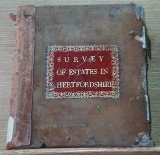
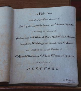
1768 - A survey, both cartographic and written was undertaken of the estate of James Lord Viscount Grimston. The map of the estate, [HALS D/EV/P.2], on the large scale of 20" to 1 mile, is coloured and measures 102" x 140". The associated reference book to go with the map [HALS D/EV.M39], lists all the individual field units with names, former names, land use, and acreage. [S167, p.131]
As this map was drawn only 2 years after the Dury and Andrews map, there is virtually no difference in the layout of lanes, roads and principle properties where they correspond. However this map is to a far greater scale, and so a wealth of extra detail can be shown; not least of which, if used in conjunction with the Survey, is the name of the owner and occupier/tenant farmer of each main farm or dwelling house. For full details, including photographs and transcripts, please click here.
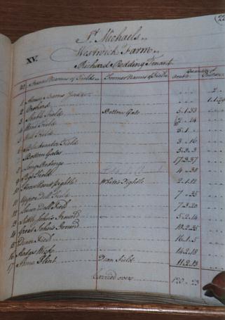
The map itself is very beautiful, and for anyone with the time to spare it is well worth going to see at the County Record Office in Hertford. It is not, however, in perfect condition, due largely to the fact that it was constructed out of many small sections, which over time have begun to separate from one another. It is, however, perfectly clear and legible. All the field names are inscribed on the map, and colour codes as well as reference numbers are used so that individual farm holdings within the estate can easily be understood. For example all the fields forming part of what we now call Westwick Row Farm, and what on the map was just called Westwick, are prefixed with the number XV.
Several pages could be written on the various conclusions drawn from the map, but I will merely outline the most important here. The reader seeking further information should view the map and its attendant reference book at the Records Office. Some caution should be taken over looking at the map, however, as the reference book was not made into a leather volume until 1800 or later, and the end of the book quotes the farms which have been bought by Viscount Grimston since the original survey. As at the same time as new entries were made the map was also updated, it is easy to gain the wrong impression from the map unless comparing it to the Survey book. Bottom House Farm off Green Lane, for example, was the copyhold property of the Filmers of Langleybury at the time of the original survey, but was part of the Gorhambury estate by 1800 and as such it's fields were later marked onto the map.
Full transcripts of all the details of field names and sizes, along with the names of tenants, and the tythes paid on those farms not owned by the Grimstons, but within their Lordship, can be seen in the local libraries.
Although the buildings of the farms belonging to the estate were shown in plan, other buildings which the cartographer considered of importance, which were not part of the Gorhambury estate were shown as small sketches of houses. Thus the map showed us that The Red Lion pub - actually named on the map - was there, together with the small cottage known as Frogs Island. The Leather Bottle was also shown,(though not in the right place!) though this was not named on the map (though curiously enough it was named in the estate book). Similarly Chambersbury was shown and named. Another property drawn on the map quite clearly, was shown just the village side of Green Lane. This was in all probability the property known as originally as Stonards, or a later building on the same site.
Another property shown, but to which a magnifying glass was needed, was a small tenement shown in a very small piece of ground - no more than a garden really - near to the house now known as Westwick Warren. This small island of ground was coloured in red and inscribed as belonging to William Howe , as was the square field in the corner next to Bury Lane. As the square filled in the corner was undoubtedly the Meads, it seems possible that the house thus shown was the tenement known as the Meads. Possibly this particularly small plot of ground was the meadow named as the Little Meads in HALS document IL3 "conteyninge by estimation one acre." Other properties shown on the map, but with no references to them were in Thomas Robinson's field, just off Westwick Row, (between W. Row and the Hemel Hempstead Road), towards Corner Farm; the house Beechtree, which is now derelict by the M1 was also shown, although unnamed. Church Cottages, in the centre of the village, and on what at that time was still all part of the common or green of Leverstock Green, were not shown. As they didn't appear either on the Dury and Andrews map of 1766, I can conclude that they were not built until after 1768. Another pictorial entry on the map showed an oak tree - actually drawn in the middle of the road on the map - along the Bedmond Road and exactly in line with the boundary between the fields known as Great Coles and Further Market Lands on the St. Michaels side of the road, and exactly in line with the boundary between the land owned by Messers Chad and Ragsdale (Known to be part of the land attached to Chambersbury according to the survey book.) and that owned by William Field on the Abbots Langley side of the road. This tree was labelled as Market Oak. No property was shown near to this tree however, so the exact location of the farm or manor house of Market Oak could not be inferred from it. It does seem likely, however, that it would have been near to the tree. It is also highly probable that this was the Market Oak tree to which Miss Purvis, the teacher at Leverstock Green School in Bedmond Road, took her pupils for a run in the 19th century, and the tree under which straw trading was carried out earlier on this century. Sidney Dollimore also showed a specific oak tree called Market Oak, in the same spot in the 1930's. [SILL, S73, S113]
It was interesting to see that Pancake Lane was still called Twitchy Lane at this time. ( Previous documents showed it as Twitchel Lane in 1569 and Twitchy Lane in 1698.) The field names as shown on this map, were to change little by the time of the Tithe survey in 1840, and the entry for that year should be referred to for a resume of many of the names. To me the most charming field name was that of Grandmothers Pightle, being a field on the other side of Hedges Lane to Westwick Row Farm. I shall attempt to reproduce from my tracing a map showing some of the area bounded by Westwick Row , Blackwater Lane and the Bedmond Road, so that the pattern of the fields and their names can be seen. I have also taken many photographs in close up from the map, and reproductions of these are in the files in Leverstock Green Library/Hemel Libraries.
A full transcription of all the farms, their field names, size and owner/occupiers along with any other relevant information, has been made, and can be downloaded above. However, the names of the owners/occupiers of different properties can be seen in the table below, along with the overall size of the various holdings. The only property within the St. Michael's parish boundaries not included in this survey was that land held totally Freehold by someone other than the Viscount Grimston. This included the land surrounding what today we call Westwick Cottage, and The Red Lion PH together with the small 17th century cottage at Frog's Island, and a house marked clearly on the map just back from the junction of Green Lane and the Leverstock Green Road.
SUMMARY OF LAND IN LEVERSTOCK GREEN BELONGING TO THE GORHAMBURY ESTATE, 1768.
 (Copyhold if not Lord of Manor)Tenant Farmer/OccupierOverall Size
Kettlewells,
alias Wards,
alias Bottom House Viscount GrimstonIn Hand143a 3r 19p
Blackwater Farm Viscount Grimston Isaac Nicholls139a 3r 22p
Hill End Farm Viscount GrimstonJohn & George Holmes 271a 1r 21p
Westwick Hall
alias Bottom House Viscount Grimston Edward Basil 335a 3r 19p
House & Land at Westwick
(i.e. today's Dell Cottage) Viscount Grimston Richard Hannell9 acres
Westwick Farm
(i.e. today's Westwick Row Farm) Viscount Grimston Richard Reading 146a 1r 04p
Breakspears Farm Viscount Grimston George Astlin 67a 0r 17p
Megdells Farm Viscount Grimston William Fellows 101a 01r 24p
Three Cherry Trees Farm
alias Palmers Viscount Grimston Samuel Redding 122a 2r 35p
Lawrence Farm,
alias Bottom House (off Green Lane) Sir John Filmer Thomas Orchard 87a 2r 13p
Two pieces of land:
Hither & Further Downer Fields.
Today these fields would be cut off from the village by the motorway, corresponding with field No. 308 on the tithe map.
Jacob WeldoneJohn Sanders 8a 2r 16p
Farm at Westwick - Although not named, a comparison of field names with those in the Tithe apportionment of 1840, suggests the quite extensive lands marked on the Estate map as belonging to Samuel Ewer, (Presumably the owner in 1800.) i.e. land on either side of Pancake Lane, (including today's Westwick Farm), and between Blakes and Whites Lane, just back from Westwick Row, and leading up to Hogg End Lane. John Goulds John Sanders 95a 0r 32p
The Leather BottleThomas Kentish James Donner 3a 0r 27p
Part of Leverstock Green Fm. Thomas Towers William Finch 10a 2r 06p
House & Orchard
(King Charles II Cottage) Richard Redding Richard Redding 1 acre
House & Land at Westwick -
This was an "L" shaped piece of land stretching from Westwick Row to the main road. Where it bordered the main road, it was opposite the field known as The Harp, a little up the hill from the present-day lay-by.
?Thomas Robinson 3a 2r 37p
Field at Leverstock Green,
part of Chambersbury Farm. Richard Chadd & John Ragsdale John Ensom 2a 1r 17p
Four small pieces of land near Westwick Corner.
(This known as The Meads, and immediately opposite the sharp bend in Westwick Row)William HoweAndrew Kiff4a 1r 06p
Where the parcels of land shown on the map did not belong to the Gorhambury estate by 1800, the name of the owner of that area was shown. Also the owners of land on the Abbots Langley side of the Bedmond Road were also named. We know therefore, that working towards Pimlico from Chambersbury, Messers Chad and Ragsdale owned the orchards next to Chambersbury, then William Field held the field up to Bunkers Lane. James Greenhill had the land the other side of Bunkers Lane, with William Howe having the area just beyond the entrance to Well Farm. Thomas Tower, whom from other documents we know owned Leverstock Green Farm at this time [ HALS 80798-80800, 80821 & 80825] owned much of the land between Pancake Lane and Green Lane, and Samuel Ewer owned substantial areas around Westwick Row. A Mr. Lovett, Samuel Davis and Thomas Kentish owned land which is now part of the Industrial estate or Buncefield Depot. Other individual holding were held by William Howe, Richard Readings, and Thomas Richardson.