55 B.C.-450 A.D. approx
ROMAN ROUTEWAYS
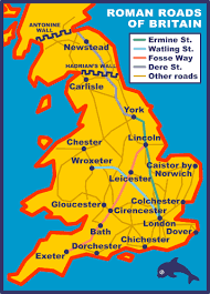
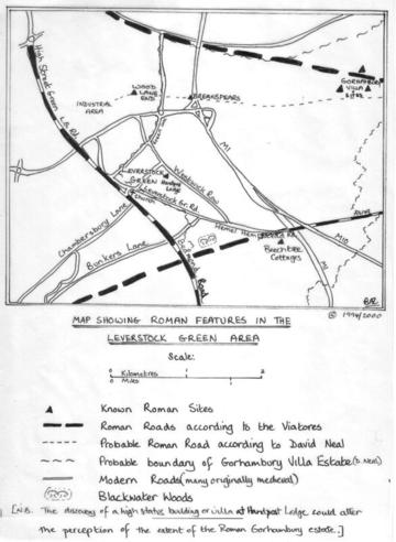
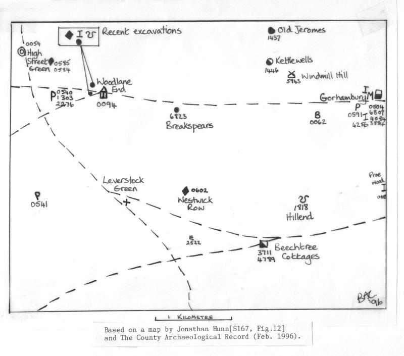
Several Roman roads surrounded the Leverstock Green area, in much the same way as the M1, M10 and M25 do today, except they were closer in to the "village.". [ S10 , S8, S11 ] . Using the system of road numbers given by Viatores, [S24], the following roads would have passed through or around Leverstock Green:
169 - Eaton Bray - Gaddesden Row - Bedmond - Elstree ( this running through the village from High Street Green, down the Leverstock Green Road, and then to Bedmond on the Bedmond Road.) According to the Viatores the road follows the line of the modern road, and in the centre of the village, roughly where the green is now, was ( perhaps still is ) the trace of a low agger - that is the embankment upon which the road was laid.
169B -Ivinghoe Beacon - Great Gaddesden - Verulamium ** ( This running from Cupid Green, crossing the very top of Green Lane ( on the N. of the dual carriageway), going through Kettlewell's Farm and Windmillhill Wood on through Gorhambury to Watling Street.)
16A - Verulamium - Nash mills - Flaunden ( This running from Verulamium in a SW direction to the Nash Mills crossroads, passing the southerly edge of Blackwater Wood, and crossing the Bedmond Road between Well Farm and Highwoodhall Farm.) [ S8; S24 ]
** However, since the Viatores put forward these routes, Dr. David Neal has established that the route of 169B differed from that given above. Beginning from the St. Albans end it travelled to the south of the Gorhambury Villa, and along a line which took it through or close to the Breakspears site, and by the Woodlane End Mausoleum, it would then have travelled in an arc and turned to join Akeman Street at Two Waters, so linking the villas at Boxmoor and Gadebridge Park with the Gorhambury Estate.
This page was last updated on: February 4, 2018
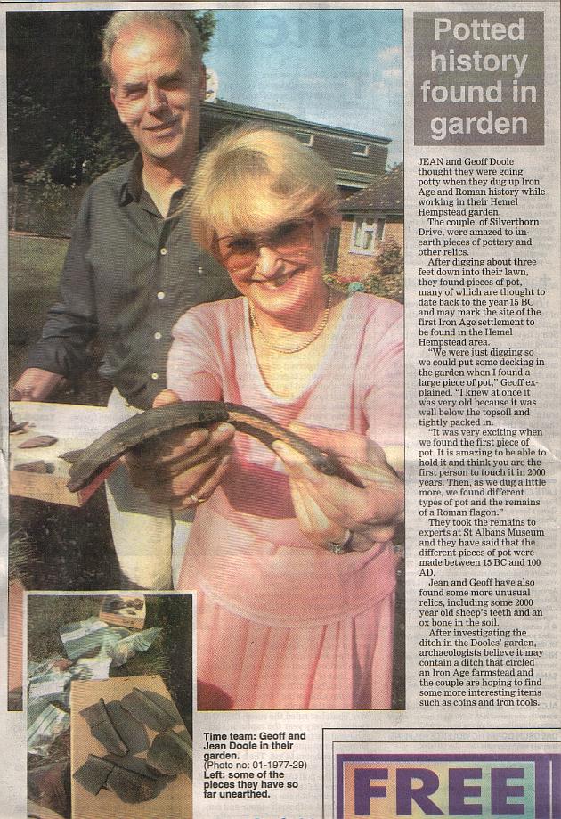
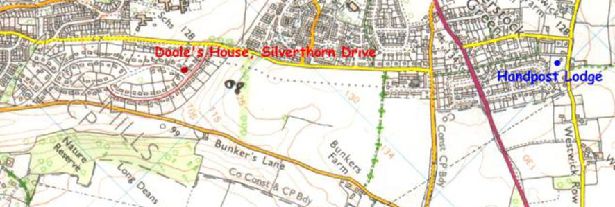
FINDS AT SILVERTHORNE DRIVE, LONGDEAN PARK
Mr & Mrs Doole of Silverthorne Drive, unearthed a large quantity of Iron Age pottery, overlaid with some Roman material in their garden. (For press report and more details see Bronze & Iron Age webpage.)
The amount of Roman material was small, amounting to a few sherds of typical Roman redware and some more interesting finer higher quality pottery thought to be a good contemporary copy of Marseilles ware. Simon West, the archaeologist from Verulamium Museum who spent some time at the site said the material was 1st century, and he thought from the evidence he could see that perhaps the previous Iron Age dwelling or settlement on the site had been deliberatly closed down by the Romans when first conquering this part of Hertfordshire, moving the occupants either to Verulamium (St. Albans) or one of the larger farmsteads nearby such as Handpost Lodge or Gorhambury) in order to have more control over the native tribes.
Mr. & Mrs Doole have very kindly said I can use their photographs of some of the artefacts found at at the site, the Roman examples of which are shown below.
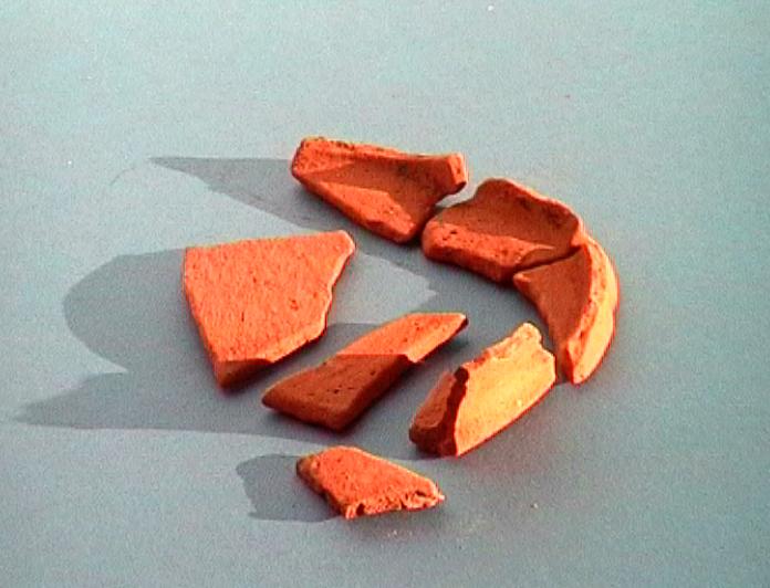
Left - some typical Roman Redware found at Silverthorn Drive
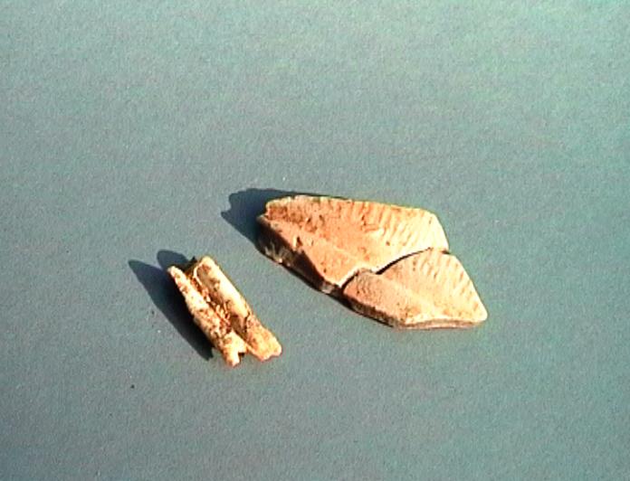
Below Left: A tooth, probably sheep's together with some fine Roman pottery found at Silvethorne Drive.
Click to link to the relevant section of this page.
Woodlane End Evaluation for Wilcon Homes Handpost Lodge Westwick Row 1998 Handpost Lodge Report 2001
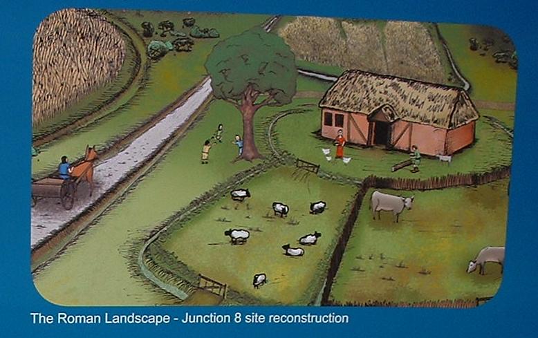
ROMAN FINDS AT JUNCTION 8 OF THE M1.
For further details on Junction 8 click here.
ROMAN TEMPLE MAUSOLEUM AT WOOD LANE END DISCOVERED 1966.
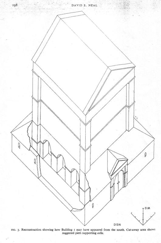
The site of some unusual Roman buildings was discovered in 1966 during construction work across the rear gardens of Nos. 98 - 108 Wood Lane End. Fortunately, the archaeologist David Neal was undertaking excavations at the nearby Roman villa site at Gadebridge in Hemel, and was able to carry out a series of weekend excavations. Very detailed reports published in "Britannia" on the findings in Wood Lane End, in 1966, and later in 1982 and 1983 when further excavations took place ahead of building development, can be read at Hemel Library (See notes S63 and S64 here.) I shall attempt a brief summary of the conclusions Dr. Neal came to below. [S63, S64]
Once having discovered and established the archaeological importance of the Woodlane End site, any development in the area will automatically attract archaeological evaluations and further finds. A watching brief carried out behind the warehouses adjacent to the Temple/Mausoleum site recorded further evidence of Roman occupation ( i.e. pits and post-holes) in 1989. In January and February of 1995 two further evaluations took place ahead of further development, one of which led to a full-scale excavation.
[ S216, CAR ref. 6824; S219; S220]
Dr. David Neal's Conclusions concerning the Temple/Mausoleum
There was no previous reason to suppose the existence of a group of Roman buildings in this vicinity, although some Roman pottery and a "rectangular plan" of a building were noticed during the construction of the M1 at Breakspears Farm about half a mile east. In Roman terms it seems unlikely that these buildings were part of the same establishment, and the Wood Lane End site is equidistant between Gadebridge
Park villa in Hemel Hempstead and the Roman sites at Gorhambury, about half a mile north-west of Verulamium. Work done by Dr. Neal has shown that the Roman road known as 169b by Viatores ( see notes above on Roman routes ), actually passed south of the villa at Gorhambury, followed the highest point of the ridge and would have linked the Breakspears Farm site and the site at Wood Lane End. It would have then joined Akeman Street near the confluence with the Gade and the Bulbourne.
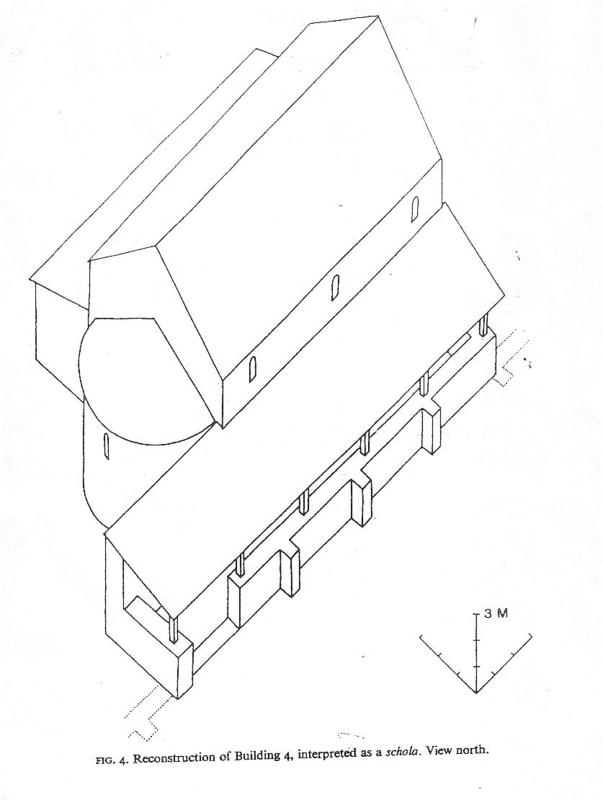
Initially it was unclear exactly what kinds of buildings had been found at Wood Lane End, but by the time the 1983 excavations were completed, five separate buildings were excavated, and the whole site is believed to have been a religious sanctuary. The principal building is thought to have been a Romano-Celtic temple-mausoleum facing south - east. Behind, to the north west, was a long buttressed wall forming a backdrop to a monument and, to the rear of this a rectangular buttressed building and an apsidal structure. Another smaller mausoleum was found lying close to and on the south - east side of the first building. Reconstructions of these buildings show them to have been very substantial, the principal building ( the cella ) would have towered at 15.5 m high excluding the roof.
Traces of walls were also found, and would appear to have formed the front of a trapezoidal enclosure (tremenos ), with ditches forming the south - west, and possibly north - east sides. There was also a small bath - suite and a curious rectangular pit. Another possible building is yet to be excavated. Midway between the temples, was a huge post - hole for a high mast or wooden column.
Due to lack of sufficient evidence there is nothing to really show whether or not all the buildings were constructed at the same time, or whether they were actually all standing at the same time. However, pottery fragments which were found suggested that the temple - mausoleum was second century A.D., probably having been constructed in the Hadrianic period.( 117 - 138 A.D.) There is no direct evidence to suggest when the site was abandoned, but again it seems likely that it was towards the end of the second century. One of the other buildings on the site was probably constructed in the late Antonine period ( 138 -161 A.D.), and demolished by the 4th century.
The bath house building was very small and somewhat crudely built, with only three main rooms : a caldarium, a trepidarium and a frigidarium, all with apsidal plunge - baths. The bath - house would appear to have gone out of use by the later second century.
Various items of native pottery, along with some samian ware makes it likely that the site was used during the first century A.D.; however this activity need not have been connected with the buildings, but with a sacred spot, such as a grove, which predated the Romans, and which was then taken over by the Romans as an ideal spot for their own mausoleum.
The nearest Roman building to the Wood Lane End site was at Breakspears Farm, half a mile away; but is unlikely to have been of great importance. This "villa" was discovered when excavating operations for the M1 were in progress. The site was examined, and a rectangular plan of a building noted. Pottery remains were thrown up ranging from the early 2nd century to the fourth century. However, as the bulldozer had already levelled it no further excavations and observations were possible.
The Roman villa at Gorhambury and its associated service buildings, was two and a half miles away, but quite possibly its estate boundaries could have corresponded with the Medieval Westwick Manor boundary, only about 300 m to the east of the site. It is therefore quite possible that the temple-mausoleum was associated with the Romano-British family at Gorhambury. However, the recent discovery at Handpost Lodge means that speculation over the posibility of an association with this closer dwelling may be more to the point.
Although the sanctuary was at a little distance from the major Roman villas, (dependant on the type of villa wenow think was to have been found off Westwick Row at Handpost Lodge), it is likely that it was situated close to a Roman road,( David Neal's suggested route for the road is slightly different from that of the Viatores,) and that this routeway was a major line of communication, and that the temple-mausoleum was a landmark which would have been seen and passed by numerous travellers.
However, relatively few votive offerings, coins,and other evidence of occupation ( so far only 290 separate pottery vessels have been discovered, which according to the experts is a small number,) have been found, which suggests that the site was little used. Dr. Neal thinks it possible that a resident curator looked after the site, and cult followers only attended on special days. The religious complex appears to have been abandoned in the late second century, and it was at about this time also that the villa at Gorhambury was abandoned. Also at this time the defences of Verulamium were being strengthened, and defensive walls were being built. There would have been a huge demand for taxes and building materials in this area, and it seems probable that the sacred site was razed to the ground, and the flint materials incorporated in the new town's defences. Certainly from about that time the site became barren, and was enclosed for cattle. It remained in use as a cattle enclosure or enclosures until the fourth century. [ S63 & S64 ]
More recent Observations on the Wood Lane End Mausoleum
It would appear that there were at least five other buildings associated with the large temple-mausoleum at Wood Lane End (Grid reference 1820 0788; CAR ref. 0094) , only some of which were previously mentioned. These were a bath-house, a rectangular cellar-type structure, a square shrine, an administrative block, and perhaps most significantly a possible granary. They were enclosed by a wall. The granary suggests the possibility that the mausoleum may have had its own land holding. This theory has been reinforced by the 1995 excavations.
From various calculations undertaken and described in detail on p.53 of Jonathan Hunn's report [S167], it would seem likely that the Wood Lane End temple-mausoleum estate would have been in the region of 2,125.4 hectares or 5,251.8 acres, an area larger than both those deduced for the villa at Gadebridge (1,799.2 hectares or 4,445.9 acres) and that at Gorhambury (91,308.1 hectares or 3,232.4 acres.) However, Gorhambury villa estate is below the average for the nine estates in the area (Boxmoor, Childwickbury, Frithsden, Gadebridge, Gorhambury, Kings Langley, Munden, Park Street and Wood Lane End) because of its proximity to Verulamium and the pre-Roman dyke systems to the north of the city.
The site of the mausoleum itself was on a Roman Road linking Akeman Street with Verulamium via Breakspears and Gorhambury. It also now seems likely that the temple/mausoleum at Wood Lane End would have been visible to and from the mausoleum discovered in 1992 within the Pre Roman Royal Mortuary Enclosure on the outskirts of St. Albans near to the City hospital ( Grid Reference 1425 0803). In other words the two temples would have been deliberately built to dominate the skylines, and to have been linked visually. [ S167 pp45 & 46 ]
OTHER FINDS AT M1 JUNCTION 8, 2006
Prior to the widening of the M1 in 2006, various archaeological work work was undertaken. Two digs at Junction 8 uncovered some very exciting material, ranging from the Iron-age through to Medieval times. Most exciting was the discovery of a 1st century Roamno-British farmstead at Junction 8. Click here for further details. These latest finds reinforce the importance of the area archaeologically and the theory of it being initially an established Iron-Age landscape which has continued to be of importance through the Roman, Saxon and Medieval period.
THE LEVERSTOCK GREEN CHRONICLE
A detailed history of one village in Hertfordshire, UK
Click to link to the following

The area we now call Leverstock Green was therefore quite a busy place during Roman times, particularly that it would now appear we had our own Roman "villa" in the vicinity of today's Westwick Row. In addition to which the Temple/mausoleum at Woodlane End would probably have attracted agreat deal of traffic. There also appears to have been extraction of brickearth for the manufacture of bricks and tiles in nearby Verulamium; and following the discovery of a report in the Hemel Hempstead Gazette for 17 May 1924 which indicated that a party from the Herts Natural History Society were shown an early Roman pot found at the Acorn Brickworks, Bennetts End; it would be possible to speculate that the brickearth available on the site was utilized by the Romans for tiles etc.[VCH; Gazette 17 May 1924]
In any case Leverstock Green's closeness to such an important settlement as Verulamium would have made its locality well known to those using the various roads, and if the Temple/mausoleum at Wood Lane End was an important religious site, then it would have brought even more people to the area. It is important to remember, however, that Leverstock Green as such did not exist at this time.
As modern roads still run more or less along the line of many of these Roman Roads, they can be said never to have entirely gone out of use. It is therefore not surprising that settlement should have developed along the line of these routes eventually. I feel sure that if we were able to bring in a full team of modern archaeologists with all the technology now at their disposal, we would find additional evidence of Roman or other early settlement in the area not already covered by modern houses. In fact in March 2001 DBC have agreed to extend "Area of Archaeological Interest 61" to include a greater ground area of Leverstock Geen so that any presently unearthed evidence is afforded at least some measure of protection. Additionally, St. Albans' district Archaeologist Dr. Rosalind Niblett is considering (as of July 2002) advising inclusion in the latest district plan of the area shown in blue on this map as an area of Archaeological Significance. (Click here for map.)
It can be seen quite clearly from the map showing the Roman infrastructure that what later became the Manor of Market Oak alias Market Dole alias Leverstock Green, and therefore the beginnings of present day Leverstock Green, corresponded almost exactly with the triangle formed by the various Roman Roads in the area. It is not beyond the realms of possibility that it was this early Roman infrastructure, which remaining through the centuries till the middle ages and beyond, actually formed the basis on which the manorial boundary of Market Oak was built. The Road which we now know as the Bedmond Road was also used as a parish boundary from the earliest times.
The Roman infrastructure can therefore be said to have had a great influence on development over the centuries in this area.
Whether you take the Manor of Market Oak as the beginnings of Leverstock Green as we know it today, or the area of common land which developed along the line of the Roman Road from High Street Green, and which was called Leverstock Green before the "village" developed; both would appear to owe their existence to the Roman infrastructure of the area, and it is now acknowledged that Westwick Row, or at least land adjacent to it has proved to have been of importance during the Roman occupation, given the recent findings at Handpost Lodge.[S353] [ Scroll further down to see section on Handpost Lodge - also See SMR map - (click here), and Westwick (click here).]
In any case the farming communities in nearby Gadebridge and Boxmoor where we know there were substantial villas, would have had an interdependent relationship with Verulamium. It is worth remembering here too, that Verulamium was the third largest city/town in Roman Britain, and would naturally have attracted people from all over the Empire, as well as close at hand. The local villas would have supplied corn, meat, building materials (tiles and lime), timber for fuel and building, and perhaps vegetables. Verulamium would have in turn offered a market for their produce, and been a source of slaves, metalwork, pottery, luxury items from across the Empire, wine and cloth and perhaps a variety of skills. There would therefore have been considerable local traffic. Whichever route they used, to travel to Verulamium from further West, they would have travelled through at least part of what is now Leverstock Green. [ S19 p.12 ]
THE LEVERSTOCK GREEN CHRONICLE
A detailed history of one village in Hertfordshire, UK
Click to link to the following

David S. Neal

THE 1995 EVALUATIONS AND EXCAVATION AT WOOD LANE END
In February 1995 two excavations were undertaken near the site of the Roman Mausoleum at Woodlane End. In both cases they were undertaken in order to record any archaeology the sites might reveal prior to development of, on the one hand a new distribution centre, and on the other where housing development was due to take place at the squash club.
I -BUNCEFIELD LANE EXCAVATION
In the first instance, the Hertfordshire Archaeological Trust had carried out an evaluation in December of 1994 on land to the west of Buncefield Lane. (NGR TL 082 080) (See location map.) The result of this evaluation led to an archaeological excavation being commissioned from the Trust by The New Towns Commissioners. This took place between January and mid February. The full interim report on the excavation, by Cathy Walker of the Herts. Archaeological Trust can be seen in the file at Leverstock Green Library.
The archaeological features found on the site were cut into the natural subsoil. Many were shallow and probably truncated by later ploughing activities. The remains of medieval "ridge and furrow" is still visible on the present ground surface, particularly to the east of the site. The excavation identified three distinct phases of archaeological activity at the site. one of which was during the Roman period.
The Roman features contained pottery largely dating from the 1st & 2nd century AD. The features themselves probably represent the remains of a field system contemporary with the known Roman temple, less than 300m to the south. It is thought that agricultural activities on the site may have helped provide food, especially grain, for the religious complex. This evidence is supported by a box-flue tile from a hypocaust, found in the fill of one of the ditches, indicating a substantial Roman building near by.

II - WOOD LANE END EVALUATION FOR WILCON HOMES .
Simon West, Field Archaeologist for Verulamium Museum , carried out an archaeological evaluation ahead of development work at the squash court Wood Lane Close, Wood Lane End for Wilcon Homes Ltd. This was carried out during two weeks in January and February earlier 1995. A full copy of the report should be available at Leverstock Green and Hemel Libraries. Below is Simon West's summary of the evaluation:
During the course of this (evaluation), four trenches were opened which confirmed the presence of very limited Roman deposits as well as several extensive areas of modern disturbance, predominantly sewer and drainage trenches. The site also appears to have been levelled for the tarmac surface of the squash club car park, incorporating a foundation rubble layer to a depth of up to c.0.5m.
The surviving Roman archaeology consisted of the temple mausoleum enclosure ditch, inside of which was a single undated posthole, and to the south outside the enclosure, a large, heavily truncated feature of unknown function was recorded. Also present were a series of burnt stakeholes, from a single phase, which were similarly undated but likely to be Roman in origin given the finds in the layer which sealed them. On the eastern side of the site this layer, probably an old plough soil, deepened from north to south as the land fell away.
The Roman finds, from all the clear-cut man-made archaeological features would indicate a date for activity on site to be some time during the late to mid/late third centuries although their small quantity and general poor quality prevents any definite conclusions. Some limited medieval activity may also have occurred. [S210]

FINDS AT HANDPOST LODGE (WESTWICK ROW)
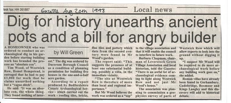
Following the granting of outline planning permission for development of 5 detached dwellings at Handpost Lodge, Westwick Row, the Archaeological Consultancy Bedfordshire County Archaeological Service were brought in during July 1998 to give an archaeological evaluation of the site. This evaluation was in two parts - a desk top survey and some excavation in the form of two machine dug trenches and 3 test pits. One substantial Roman ditch was found within the investigation area which contained a large amount of Roman occupation debris.
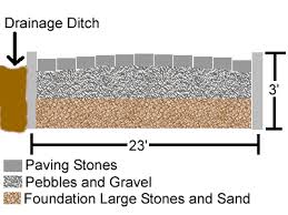
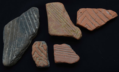
The ditch was found at a depth of 400mm within the second trench, and was visible for 4m running diagonally across the trench. Altogether the ditch was 1.8m wide and 800m deep, with steep sides and a flat base. The evaluation produced a large number of artefacts mainly comprising pottery and ceramic building material. A total of 45 vessels were found (in 81 sherds). Most were 2nd-3rd century Roman with some residual iron-age sherds and one item of 17th-18th century earthenware. All the Roman pottery finds were local in origin and included flanged bowls, everted and bead rimmed jars, and everted rim beaker and a probable mortarium (cremation urn) There was also a considerable quantity of ceramic building material found made up of tegulae, imbreces, brick and combed box flue.
A small but very interesting find was made of a probably 2nd or 3rd century cylinder bead in opaque blue glass.
It would appear that the majority of the artefacts come from the disuse fills of the ditch and appear to have been an occupational rubbish dump. The nature of the material found, both in its quantity and quality indicate that it had not travelled very far. This together with the Roman roof tiles bricks and flue tiles suggests the presence of at least one substantial structure in the vicinity of today's Handpost Lodge. This building would have had a tiled roof, and even more significantly a hypocaust heating system. [S326]
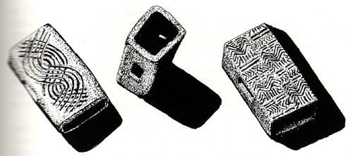
Box Flue tiles from hypocaust systems
(from other sites)
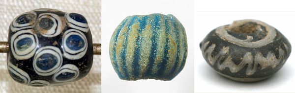
Typical Roman Blue Glass Beads.
(found elsewhere).
WORK ON THE SITE IN THE YEAR 2000
Eventually full planning permission was granted,subject to certain work being undertaken. Unfortunately the builder started to dig footings etc. WITHOUT carrying out the necessary work. Fortunately as a result of reports from neighbours, Dacorum Borough Council were able to have an injunction enforced and work stopped for a while. Unfortunately, though inevitably, some of the archaeology was lost. Following this, work continued with the correct archaeological presence on the building of the six houses. The cul-de-sac of houses, now called Handpost Lodge Gardens, is now complete and well established.
EXTRACTS FROM THE BEDFORD ARCHAEOLOGY SERVICE REPORT
ON HANDPOST LODGE, 6TH MARCH 2001 (DOCUMENT 2001/13)
It is proposed that the results of this work be published in Hertfordshire Archaeology. For further details and information
e-mail bcas@dial.pipex.com
FROM THE NON TECHNICAL SUMMARY:
Investigations have revealed at least three phases of human activity:
1. Late Iron Age -comprising a single pit, although the quantity of contemporary pottery within later features suggests activity was more extensive.
2. Early-Roman - two ditches, including one traced across almost the entire development area. One of these contained significant quantities of Roman building material, including brick, roof and flu tiles. The presence of these suggests the construction of a substantial building in the vicinity. The recovery of flu tile indicates one of the rooms may have had an under-floor heating system (Hypocaust).
3. Later Roman - four postpads in an approximate alignment probably represent the wall of a timber building.
The presence of pottery and general building debris is often used by archaeologists to classify sites such as Romanised farms (villas). The development area is situated in the vicinity of several Roman villas. Nationally, various attempts have been made to define villa estates and the interaction between them and towns. Due to the large number of known sites in this part of Hertfordshire, including Gorhambury, Gadebridge, Boxmoor & Kings Langley surrounding the Roman town of St. Albans, this area is frequently used in such studies. The new site within the development area, will, therefore add to this discussion and makes the discovery of more than local importance.
Methodologies and resources required to complete the project are detailed in this document. This will result in a publication within the county-based archaeological journal, with summary notes placed in regional and national publications. Once completed it is hoped the material will be archived with Dacorum Heritage Trust, (to view their website www.hertsmuseums.org.uk/dacorum click here) where it will be available for examination, both by interested local people and academics.
EXTRACT FROM PROVISIONAL SUMMARY OF RESULTS:
2.4 Roman
The majority of the pottery and features discovered during the investigations date to the Roman period. The features investigated comprised two ditches (one due to its size probably a boundary) and four post pads. The latter probably represents the foundations of Roman timber building. A more substantial building in the vicinity is indicated by the discovery of Roman building material (including I tegulae [(Plantin OUP:A flat roof-tile, used esp. in Roman roofs., imbreces, [(Plantin OUP: -A curved roof-tile used to cover joints in a Roman tiled roof.] bricks and flu tile) and one fragment of window glass. The development area is located within 2.5km of substantial Roman buildings/villas at Gorhambruy/Wood Lane and Breakspears. In addition a number of undated cropmark sites occur within 1km. These (SMR 8545, 8548 and 9038) [Click to view SMR map] may be Roman (or Iron Age) in date and suggest a fairly intensively occupied landscape during this period.
EXTRACTS FROM ARTEFACTUAL DATA
3.3.1.4 Chronological summary by Pottery Date
The pottery dates predominantly to the early Roman period, with a small proportion of late "Belgic" Iron Age material. The lower average sherd weight and more abraded condition of the latter comparison with the former support the suggestion that it is largely residual within later features. Negligible quantities of post-medieval and undatable pottery were also identified.
Late "Belgic" Iron Age (24% total assemblage)
(for details see http://bacchronicle.homestead.com/BronzeandIron.html )
Roman (73% total assemblage)
The Roman material dates predominantly from the late first to second century.....Coursewares are represented a standard range of local greywares (R06), oxidised sandy wares (R05A, R22A, R36) blackwares (R07) and whitewares (R03, R33).
Regional imports are not present in large numbers. ..............Continental imports are represented by seven sherds from Spanish Dressel 20 amphorae. Surprisingly no Samian ware was recovered.
Diagnostic forms include flanged and reeded rim bowls, everted, bead and triangular rim jars, single examples of cordoned and necked jars, an everted rim beaker, a dog dish, amphorae, and a probable mortarium. (Plantin OUP; ;A Roman vessel for pounding or grinding.) Decorative elements are restricted to horizontal grooves, simple zonal burnishing or burnished lattice motifs.
Vessels recovered are indicative of a domestic assemblage, comprising tablewares and cooking pots, suggesting the accumulation of settlement debris.
3.3.2 Ceramic Building Material
Fifty-nine fragments of ceramic building material weighing 5.5kg were recovered..........
Twenty-eight fired clay fragments weighing 487g were recovered............
3.3.3 Non-Ceramics
A total of six registered artefacts (RA) and four iron nails were recovered. Processing and sorting of ecofactual samples produced one additional artefact. The majority of these artefacts (over 90%) derives from the boundary ditch fills.....They probably represent either accidental loss, in the case of personal items, or, in the case of domestic items, the redisposition of settlement debris. Despite extensive metal detecting only a single quernstone fragment was recovered from the topsoil.
THE ROMAN ESTATE AT GORHAMBURY
Although the actual villa and other Roman settlements at Gorhambury, now fully excavated by Dr. David Neal and others, are just outside the area of this study, it is thought highly probable that the estate belonging to the Roman settlement at Gorhambury, would have corresponded almost exactly with the medieval estate of Westwick. A large proportion of the land within our study area, would therefore have been part of this estate and subject to control from the Romano-Britain's who owned and had farmed, the estate.
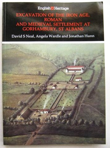
A full account of the excavations undertaken by David Neal and his team, of the Roman and Medieval sites at Gorhambury can be read in the English Heritage Archaeological Report no. 14 - "Excavation of the Iron Age, Roman and Medieval settlement at Gorhambury, St. Albans" - several copies of which are in the St. Albans Library, and which can also be purchased at the Verulamium Museum.[S103] or various sources via the Internet.
Calculations based on the cubic capacity of the granary excavated at Gorhambury suggest that it was capable of storing about 88,000lbs of grain; being the yield from about 750 acres of medium land. As this is more than double the area which was part of the main farm of the medieval manor, it would seem reasonable to me to assume that much of the land in the area was used as arable land rather than being left as woodland, and I conclude therefore that landuse in our study area during Roman, and subsequent times, would have been similar to that in the eighteenth century, that is predominantly arable, with only a small area of woodland. [S103, pp 100 - 102]
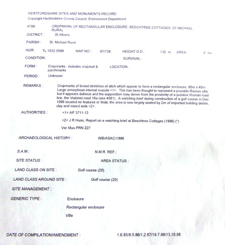
ADDITIONAL SITES
When first undertaking my research, another Roman "find" in our area of study is that of a possible Romanised farmstead at Beechtree Cottages (Grid Reference 1032 0588, old CMR ref. 4789 ). This was established by aerial photography, the photographs having been taken on 3 May 1971. Looking at the photographs (there are three -Photograph numbers 3711, 3712 & 3713, HSM Photographic Data dated 25 Jan 2000) The remarks stated " Oblique AP showing cropmark of a possible rectangular building [4789]".
The outline of the structure appears to me to be very clear to see, even to the untrained eye. One argument against the possibility of its being a villa is its position on the central plateau away from the river valley. However, my feeling is that it may possibly have been some kind of functional outpost of Verulamium as it stands at the "confluence" of two Roman routeways, where the route from Verulamium, following the present line of the A4147 veers off towards Nash Mills, [CAR. ref. 4595], and where the track or road from the Leverstock Green direction approaches Verulamium approximately along the line of the A4147.
It had been hoped that an excavation could be undertaken here at some future date; unfortunately however, permission was given to develop a new golf course, work on which began in November 1996. The new club - THE CENTURIAN CLUB - finally opening on 7th August 2014. As the creating of the golf links would not apparently destroy any underlying archaeology, exploratory excavations could not be insisted upon. Instead a Watching brief was established with Jonathan Hunn overseeing this. Subsequently the SMR was changed and in the printout I was sent in 2003 it "appears dubious" - see report below.
BENNETTS END BRICKWORKS - It would seem that early Roman pottery was found at the Bennetts End brickworks off Tile Kiln Lane in the 1920's. A report in the Gazette for May 17 1924 (page 2 , Heading: HERTS NATURAL HISTORY SOCIETY) concerning the recent visit of society members to the brickworks to look at the gravel/clay pits, stated: "Mr. Norris, the owner of the brickworks, exhibited some early Roman pottery which had been unearthed and some huge blocks of "Pudding Stone"........


If you are reading this and know of any Roman finds in the Leverstock Green area not already mentioned, please CONTACT ME. Thank you Barbara Chapman
In the summer of 2008, Channel 4's Time Team excavated the historic remains of what are believed to have been four Romano-British temples in Friars Wash, an area of land just outside Redbourn and off of the A5. The programme was aired in Jan 2009. Re watching the programme in Aug 2015 it occured to me their might well be a connection between the Temple Mausoleum at Wood Lane End as well as the one found near the old hospital site in St Albans. The three sites forming a triangle. Comments Welcome.


It always seemed probable to me that in addition to the above mentioned roads, the route of the present Hemel Hempstead Road (A4147) would have dated back to Roman Times. This has now been established, and Jonathan Hunn shows quite definitely that it was a Roman Road. [S167 p.23]
Click on original 1994 map/key for full sized view.
Click on 1996/2000 map/key (R) for full sized view.
Click on thumbnail to get a much larger image on new page.
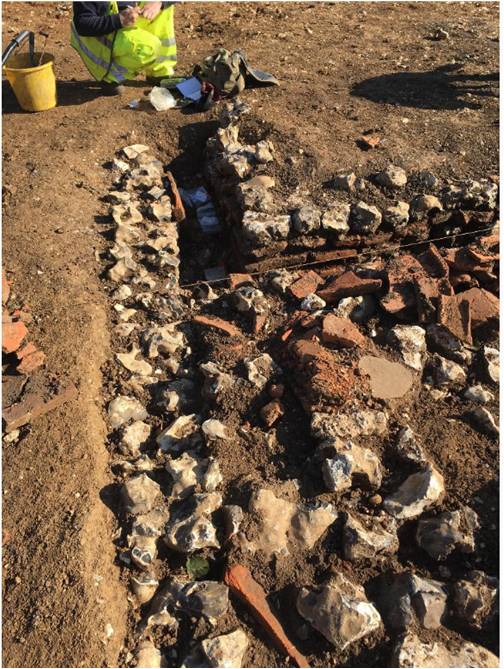
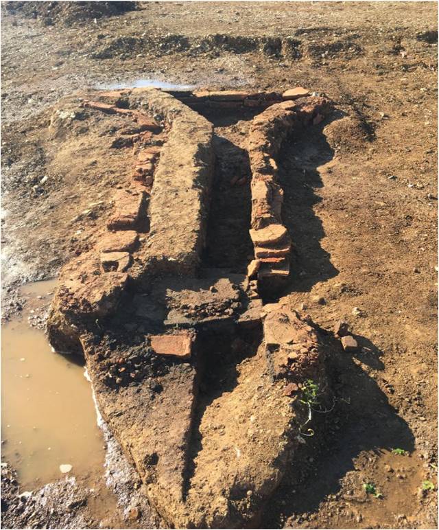
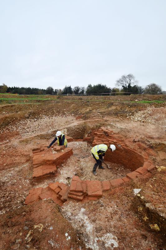
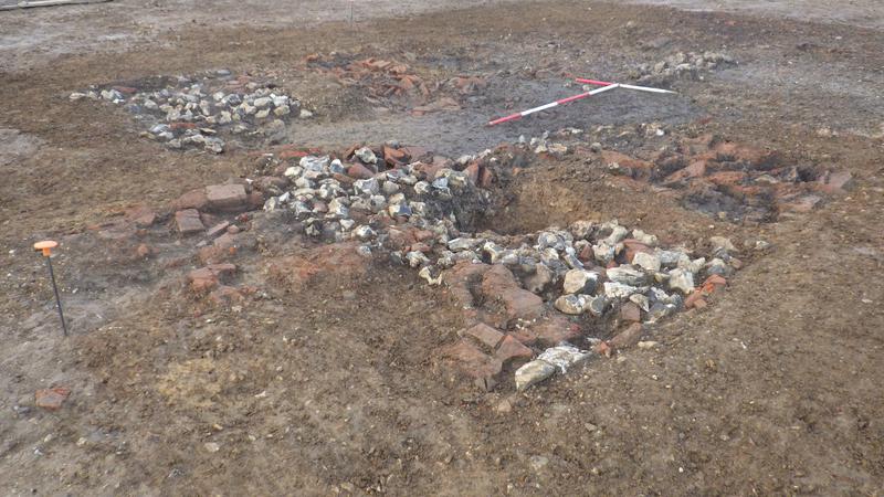
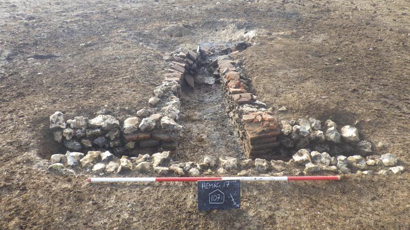
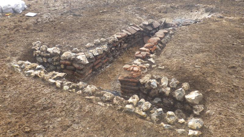
FINDS AT MAYLANDS GATEWAY SITE OF
IMPORTANT ROMAN ARCHAEOLOGY 2017
© Oxford Archaeology
© Oxford Archaeology
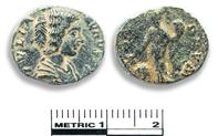
Roman Denarius found at the Maylands Gateway Dig 2017.
It is a denarius of Julia Domna (the wife of Septimius Severus). She was Augusta (empress) from 193-217. This coin is dated AD 198.
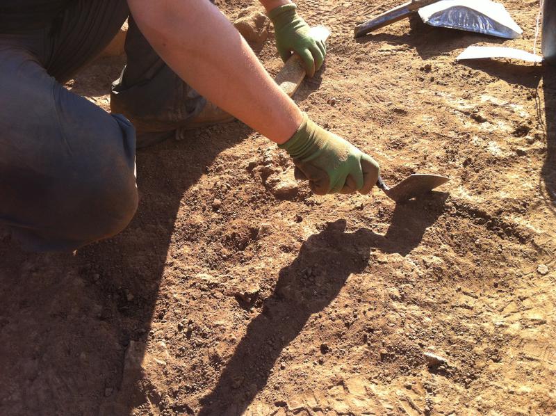
In the summer of 2017 I was made aware by concerned residents, that an archaeological dig was in progress on the area which has been called the Maylands Gateway development. One of the residents visited the dig whilst it was on-going and took some photos of her own (se Gallery below) as well as talking to the archaeologists about their finds, which turned out to be Roman. When I heard this, knowing of the important find of a Roman Mausoleum by Dr. David S. Neal almost adjacent to the site, I alerted members of HHLH&MS and Dr. David Neal. Dr. Neal paid a visit and was very interested in what they had found.

Click to view enlarged photo - Hover to view label if one.
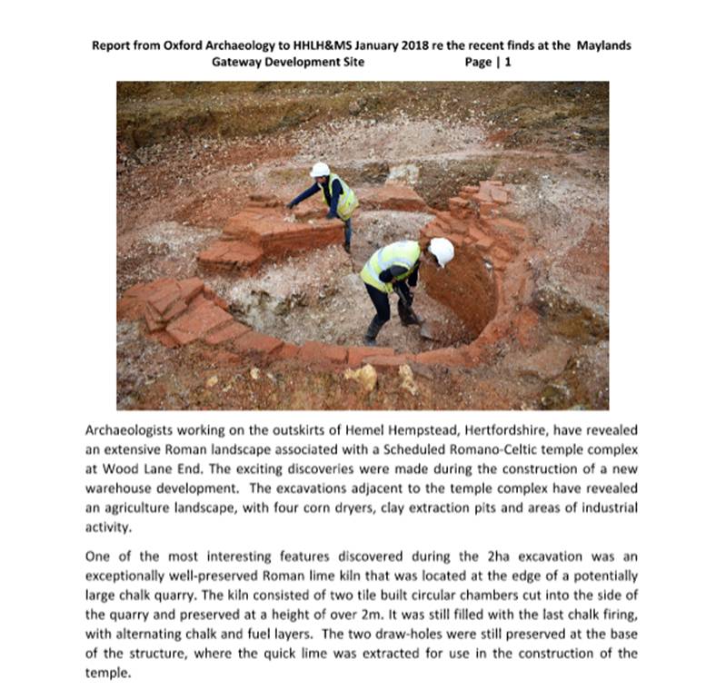
Mike Stanyon had also contacted Dr. Neal, as well as Oxford Archaeology who were undertaking the dig to see what else we could find out. I also contacted DBC as it transpired documents which should have shown up on their planning site, were no longer there. Mike & I found that Carl from Oxford Archaeology, was very helpful and promised to keep us informed. The report below is a summary of their findings from Oxford Archaeology which we were sent in January 2018, together with a large number of additional photographs. I also eventually received from DBC a series of documents covering the last few years detailing all the stages involved in preliminary digs and scans. These individual documents, containing maps and photographs were originally made available to the public on Dacorum Borough Council's Planning Applications site, can be downloaded FROM HERE.
Click on the above to download the whole report
( 3 x A4 pages)
I will in due course properly scan the whole report to show as 3 much sharper jpg pages.
That to the left, was taken from Powerpoint and is not really sharp.
© Oxford Archaeology
© Oxford Archaeology


To be continued
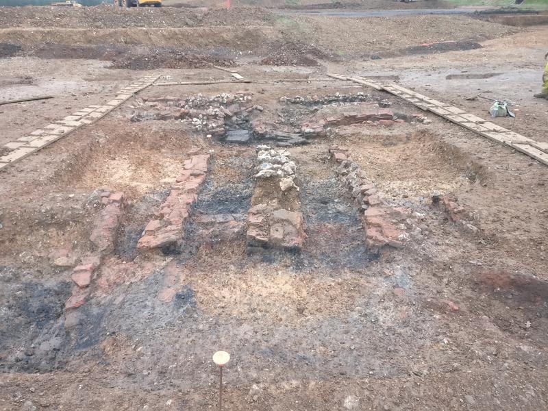
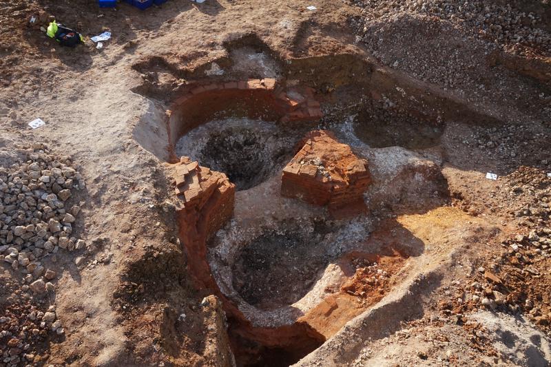

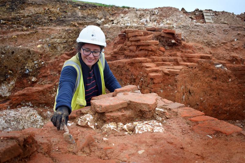
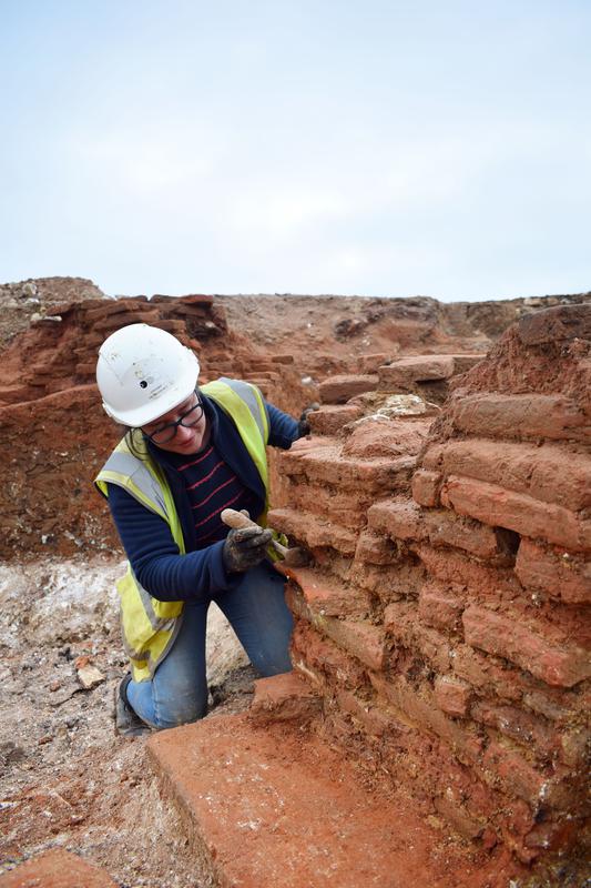
GALLERY OF PHOTOS TAKEN ON THE DIG BY OXFORD ARCHAEOLOGY - WITH WHOM THE COPYRIGHT RESTS.
© Oxford Archaeology
© Oxford Archaeology