THE BRONZE AGE/EARLY IRON AGE .
The next indication we have of any activity in our area is a bronze hoard discovered by John Evans at Westwick Row about 150 years ago. [SMR 602. Click here to link to SMR map. This consisted of a looped socketed bronze axe, fragments of another axe and five lumps of copper. With the exception of one lump of metal which John Evans donated to the British Museum, the rest of the find is at the Ashmolean Museum in Oxford. The axes appeared to have been imperfectly cast or unfinished, as if they were found on the spot where they had been manufactured. Possibly the site of the find was the open air workshop or forge of an itinerant smith. This does not, however, necessarily imply that there was a Bronze Age settlement at Westwick Row, as itinerant smiths frequently built small furnaces at suitable sites and then moved on to another site next time they wished to smelt their metals and cast some tools. [VCH; S167, pp21, 22 & 217; S216, CAR ref. 0602; S226; S171 p.21; S186; S187. Click here to link to the Source references for the Leverstock Green Chronicle.]
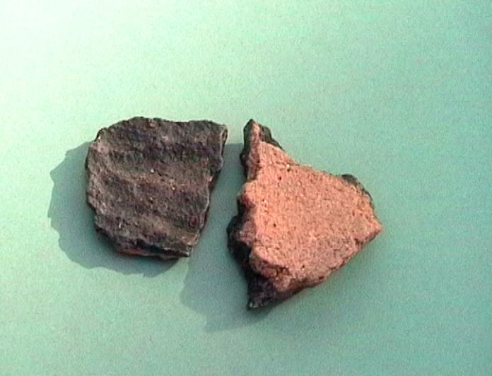
Until recently that was the only indication we had of possible settlement during this period in the immediate area of Leverstock Green. However in February 1995 the Hertfordshire Archaeological Trust carried out an excavation on land to the west of Buncefield Lane. The excavation had been commissioned from the Trust by the New Towns Commissioners prior to the development of a new distribution centre. The excavation identified three distinct phases of archaeological activity at the site. The first phase being from the Bronze Age/early Iron Age period and showing distinct signs of occupation, though no definite structures in the area. The most interesting features included a hearth-dump and a large ditch terminal. A hearth dump was a pit into which the spoil ( ashes and other debris from a fire) from a hearth was put.
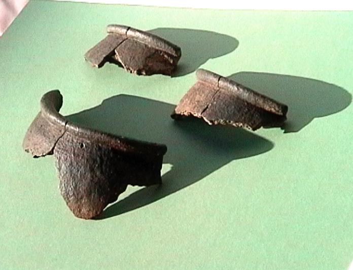
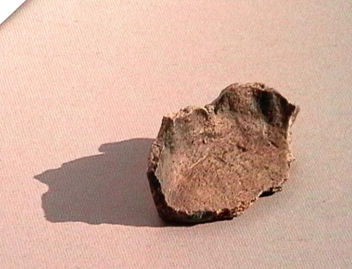
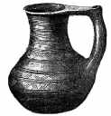
A significant quantity of pottery was recovered from the various Bronze Age/Iron Age features. A particularly nice find was a large triangular "thatchweight" or heavy loom weight, found in the primary fill of the hearth-dump. A line of several postholes was also found, suggesting the presence of some kind of structure. The archaeologists did not, however, identify any specific building, and it would appear that occupation was on a small scale rather than long-term or intense. [S219]
Again Christopher Currie in his field walking during August 1998 also came across evidence of Bronze age activity close to Westwick Cottage. This and other evidence he came across whilst undertaking his survey has let him to suppose that settlement in and around Westwick Row was probably fairly continuous from Bronze age times, and no doubt formed an important hinterland site to the Opidum at Prae Wood St. Albans. [S327 - also see previous section.]
LATE IRON AGE /PRE ROMAN PERIOD
Until recently no specific finds relating to this period had been found in our study area. However it must be remembered that there is considerable evidence of pre Roman settlement in the Prae Wood and Gorhambury area, also at High Street Green and Adeyfield. [S216]
However, preliminary fieldwork 500m north of Westwick Row in advance of the proposed widening of the M1 motorway, revealed evidence for a prehistoric industrial site, with large numbers of flint "hammer stones" and worked flint flakes. These probably date from c 2000 BC or earlier. [S290]
The position of Westwick Row on the upper slope of a dry valley, is one that was particularly favoured for settlement sites in the pre-Roman Iron Age, and throughout the Roman period. [S290]
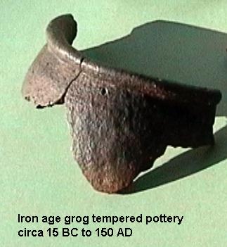
More recently in July/August 1998 an archaeological evaluation undertaken at Handpost Lodge Westwick Row, and which included two test trenches and several test pits, unearthed evidence of iron-age activity along Westwick Row. Four examples of shell tempered and locally manufactured grog/sand vessels of "Belgic" type of a residual nature were found along with the Roman debris in trench 2. [S326]
It is also a matter for conjecture, and with no real concrete evidence to support it, but it is possible that the line of the original Buncefield Lane/Westwick Row formed part of an ancient trackway, perhaps linking the area around Markyate to the area of the iron-age settlement in Prae Wood. My attention was first drawn to the possibility of the line of Buncefield Lane and Westwick Row - and others - being linked by Alan Greening, the Architectural Historian who has worked on Westwick Cottage and other property within Westwick Row. He suggested that if you looked at the original 1st edition O.S. maps you could see that the lanes were connected and continued from Markyate and through to join with the end of Buncefield Lane at the crossroads with Three Cherry Trees Lane and on through to Westwick Row and beyond towards Abbots Langley, or the southern approaches of St. Albans. Thinking on what Alan said, and looking at the maps myself, it was even possible to trace the apparently continuous line of routeway on a modern !:25000 O.S. map. However, my knowledge of Westwick Row itself and the pattern of settlement there, suggest that the trackway, if that is what it was, would have been in existence before the middle ages, and would at the very least been of Anglo Saxon origin, but reinforced during early Medieval times when it may have formed a pilgrim's approach to the Abbey from the southern end of Holywell Hill.
Giving the matter considerably more thought, and studying the pattern of the very old roads etc. it occurred to me that it might even have been earlier still. Bronze-Age and Iron age artefacts and evidence of settlement have been found in recent years just off Buncefield Lane. Sir John Evans found Bronze- Age horde along Westwick Row, and Prae Wood, a major Iron Age settlement. The apparent continuous trackway linked them all. This seemed even more likely when I discovered quite by chance from a school book in a school at which I was teaching on supply, that there was supposedly some pre-Roman settlement in the Markyate area. I had previously only though of Markyate from early Medieval al times, when it was a centre for religious hermits, and later a nunnery founded by Christina of Markyate in the 12th century. The book I was reading included a fictional tale about a boy living in an early iron age village in the Markyate area, and included some legend. If a trackway was formed linking the iron-age settlement in what became the Markyate area to the settlement just outside St. Albans and now part of pre Wood, then the development of further settlement along the route at various points in time, makes more sense. The results of the archaeological evaluation at Handpost Lodge in July/August 1998 only serve to reinforce the idea that Westwick Row may have formed part of a very early trackway or drovers route.
With this discovery it immediately seemed to me that perhaps the whole local landscape is basically of Iron-Age rather than Roman Anglo-Saxon or Medieval in its origins. Occupation on previous Iron-Age sites was often continued in Roman times, and in the case of settlement along Westwick Row, this continued through the Anglo-Saxon and Medieval periods to the present day.
Looking at the 1877 6" OS map, the "removal" of the Roman Roads (Bedmond Road and St. Albans Road - now A4147) shows many of the field boundaries to run from Westwick Row SW in the general broad S "furlong ploughing" pattern which is typical of the area. Not all the boundaries match exactly, some are "near misses". In other words they were there BEFORE the Roman occupation of the area. This therefore leads me to suppose that these ancient field boundaries and "hollow ways" were not Medieval, or possibly even Anglo-Saxon as previously thought, but instead date from at Iron Age.
The line of Bunkers Lane/Blackwater Lane and the field boundaries between Westwick Row and the now A4147 can be traced in quite easily, so that it can be seen that the Roman routes came afterwards and subsequently dissected them. Click here to view sketch map showing some of these possible Iron Age boundaries and Lanes. When travelling along Bunkers Lane & Chambersbury Lane it is immediately obviousl that they are ancient lanes; in many places the road is deeply incised into the landscape, worn down through the stratigraphy over centuries of use; the hedgerows are obviously also ancient. This is particularly clear around the kink in Blackwater Lane where it can be seen very clearly that the a supposed Roman route to St. Albans bisects the field pattern. (This was pointed out by Chris Currie when he was undertaking his work for the Crown Estate.)
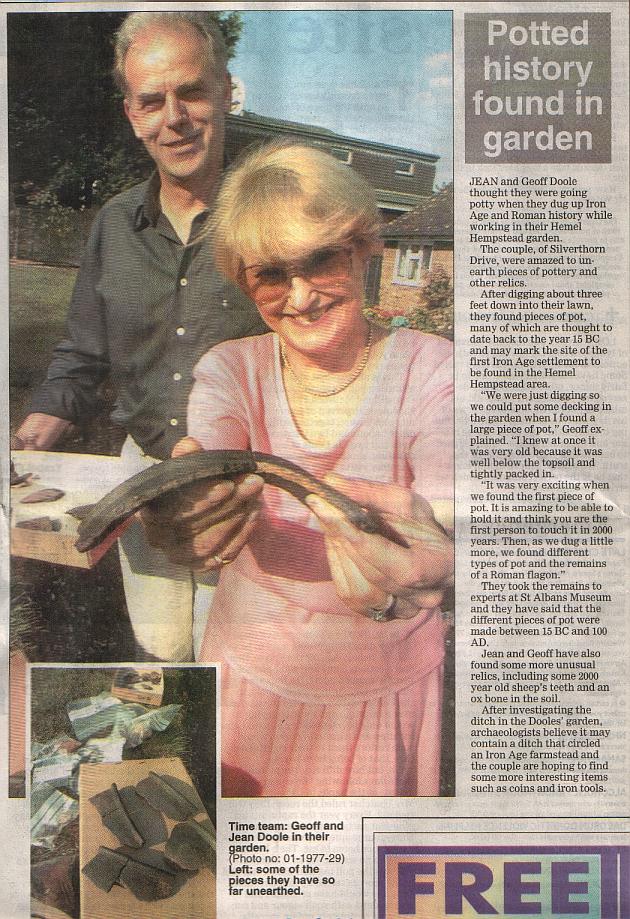
It therefore seems to me that the Blackwater/Bunkers Lane, route, was in fact a trackway linking the probable settlement along Westwick Row with what has now been discovered just off Bunkers Lane at Silverthorne Drive. Even more astonishing, as before looking at the map it had not seemed so obvious, was the link from the site at Handpost Lodge to where Chambersbury Lane meets the present day Silverthorne Drive. Silverthorne Drive itself follows the natural contours of the land as can be seen quite clearly if looking at a modern OS map. Click here to see map.
This then also seems to beg the question, if these field boundaries/trackways are as old as the Iron-Age, can we presume the whole pattern of "s" shaped furlong field boundaries throughout much of the Chilterns dates to that age as well? If such a large area was down to the plough so early on, that also suggests to me a much larger Iron Age population in the region than has been considered possible before.
I have since discovered that the boundaries actually directly connect between the Handpost Lodge site and Silverthorne Drive [click here to view map] (which incidentally follows the natural contour of the land.) This seems to me to strengthen the theory, as Iron Age folks living so close to one another would probably have some interplay with one another. On the map Silverthorne Drive is shown as a red line, the Handpost Lodge site as a green splodge. I've marked what I consider major Iron Age trackways (because they are obviously ancient routeways rather than just field boundaries as they are all in some places incised into the landscape due to the continual wear over the centuries (or millennia!). The orange field boundaries shown how they could have been prior to the Roman Routes, though there could well be many more.
Who knows how many more Iron Age sites will be found in the area in the future to further reinforce this idea?