One of the items to be shown on my infrastructure map is the tithe barn. (Click here to view map) I am now as certain as it is possible to be without undertaking an archaeological dig, that the tithe barn was, up until it's demolition in 1633, in the position shown. (i.e. in the field known as The Urchin in the Tithe Record of 1840, field No: 283.) When the barn was erected I am not sure, but it is quite possible, though by no means certain, that the barn referred to in the survey of 1306 was the same one. (See entry for that year.)
The farm house associated with it, from the evidence of the 1569 survey, was the demesne or "home" farm for the manor of Westwick. This property was on the other side of the Row to the barn, standing a little back from the lane, as the Benjamin Hare map of 1634 shows quite clearly. By the survey of 1696, this farm house would appear to have been demolished. How did I decide that the barn was in the position I have shown? A friend of mine recently said that I have a jig-saw mentality, delighting in fitting little pieces of a puzzle together, until they all make sense. In effect this is what happened over the barn. Mentioning the pieces of the puzzle chronologically might help the reader to follow my reasoning. I have used the spellings of names as given in the documents referred to, hence the same name is not always spelt the same way.
1. In 1569 Henry Knight held the "Farme House and Homefield", the "farme and lands.... being demesned of the saide mannor of Gorhambury and Westwick/lying without the park." It was the only farm given in the survey as belonging to the manor itself, Henry Knight being a tenant of Sir Nicholas Bacon, not a Freeholder or Copyholder. [HRO XI2]
2. In 1599 Richard Laseby and Thomas Fynche were granted a moiety each of the "messuage, orchard, garden and backsyde, sometime in the tenure of Henry Knight, deceased, and in 50 acres of land" etc. A moiety is a half-interest. [HRO IM14/ IM14a]
3. In May 1611, Thomas Fynche and Robert Laseby (Richard's son) agreed to divide the land between them.  [HRO IM18/IM19]
4. In June 1614 William Prior surrendered the Great Barn and 2 acres of land to John Crosbye and Walter Finch, viz., a moiety to each. [HRO IL28]
5. Walter Finch died in 1626, leaving his moiety of the Great Barn to his brother Thomas Finch. [HRO IL29]
6. In April 1631, Daniel Finch took over the moiety of the Great Barn and the adjoining land, from his father Thomas Finch. [HRO IL30]
7. In May 1633, Daniel Finch paid the Lord of the Manor 10s. for a license to ruin and pull down a barn at Westwick containing 4 bays. [HRO IL31]
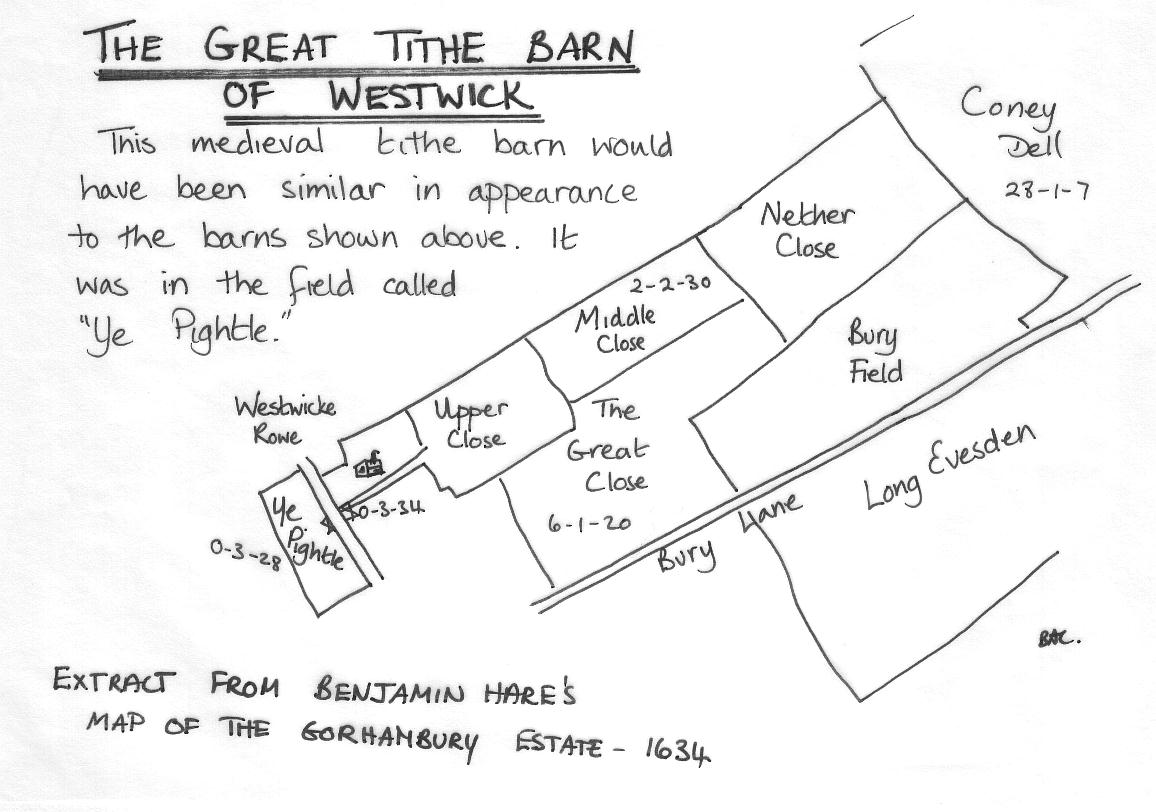
8. The Hare map of 1634 showed quite clearly that the only farm lying outside Gorhambury Park, and being part of the estate was situated roughly where Westwick Warren is today. (See photograph of map and the extract on the page referring to the Great Tithe Barn.) It therefore had to be the same farm as let to Henry Knight in 1569. This despite the details in the survey which at first sight suggest the farm may have been further up the Row towards Westwick Row Farm. The map below also shows quite clearly that the field on the opposite side of Westwick Row to the farm house, called Ye pightle, was only 3 roods 28 poles in size. The area of land immediately around the farm house was given as 3 roods and 34 poles in size. [HRO D/EV/P1]
8a. In February 1637 Thomas Meawtys, Thomas Coningsby and Robert Coningsby let various property to Richard Field. [HRO IL1] Correlation of known field names over the period 1569-1798, and the subsequent lease of the same land to John Waller in 1658 when Field's 21 year lease expired, showed that the land shown in the sketch map accompanying the 1696 survey [HRO IA 68] was the same land leased to Field in 1637 and also much of the same land as leased to Henry in Knight in 1596.
9. In 1658, when Sir Harbottle Grimston agreed to have Westwick Hall built and let to John Waller as the new "home-farm" for the estate, part of the indenture granting him Westwick Hall and the various lands that went with it said:
"And all that Homestall where the old house now or doth or lately did stand with the yards and Orchard belonging to the sayd Old House conteyning by estimation three roods. And all that pightle of pasture ground nere the sayd old house where the tythe barn formerly stood called barne pightle conteyning by estimation three roods, And all that pightle of land or pasture ground next the sayd old house and Orchard conteyninge by estimation two acres." [HRO IL3]
It is therefore possible to correlate all the above information and come to the conclusion that a Great Tithe Barn, some 4 bays in length had prior to its demolition in 1633, been in the field of approx. 3 roods in size, which was shown as being opposite to the "home-farm" or "Old House" in the Hare map of the following year. This supposition was further reinforced by the survey and attendant sketch map of Westwick Hall, undertaken in 1696 as part of the estate survey of Sir Harbottle Grimston, where the list of property again refers to the Old House and a Barn Pightle, showing the same small field to be of 3 roods and 28 poles in size. [HRO IA68]
It is also interesting to note on this sketch map (1696) pertaining to Westwick Hall, that although a "picture" of a house is shown off Westwick Row , there is no corresponding picture of a house at the site where Westwick Hall is to be found, merely a point were several fields come together, and their respective field gates. In all the other sketches undertaken in this survey a pictorial impression of the relevant dwelling is included. It poses the question, was Westwick Hall completed before this sketch was made?, or did Waller still reside at the old house?
Later maps show Ye Pightle to have been given the name of The Urchin, a name it was to retain at least until the Tithe survey of 1840. Restrictions placed on John Waller in the Indenture dated 1655 ensured that the small field was not to be ploughed, so retaining a field of less than an acre in an otherwise larger field. In fact it was the apparent incongruity on the 1840 Tithe map of such a small field divided from an already not overlarge field, which in turn was sandwiched between Westwick Row and The Hemel Hempstead Road, that led me in the first instance to ponder why such a small field existed at all. [HRO IL3; S96] Even if this barn was not the same one as mentioned in the survey of 1306, it must have reached a great age by the time of the dissolution. It would have stood just off Westwick Row for many years if not centuries. Tithe barns were in essence medieval structures, used to store a tenth of the income from both the produce of the estate, the stock and the income derived from labour - this was usually given in kind. These tithes went to help support the Rector of the local Church each year. Where, as frequently was the case, the Rector was a monastic order who appointed a Vicar as incumbent, then the tithes went to that monastery or convent. From 1391 monastic Rectors were obliged to use some of their tithe income to support the parish poor. In this instance it would have been the Abbey at St. Albans which was Rector, and who would have collected the tithes. After the dissolution it became more common for a monetary value to replace these tithes, the right to which were sold off by Henry VIII along with the lands belonging to the monasteries.
Various accounts relating to the manor of Gorhambury after the reformation show that the tithes were paid to the Lord of the Manor in coin of the realm for the most part. Such a large barn, used to store the grain and goods paid as tithes had obviously become a white elephant. Hence it was no longer used for its original purpose, and eventually Daniel Finch obviously considered that he could put the land upon which it stood to better use.
What would the barn have looked like? Tithe barns were good functional buildings usually built of random stone, and massive in size. Particularly when built my monastic institutions, they were amongst the largest structures of the Middle Ages as they were built to receive a tenth of the produce from the large estates belonging to these monasteries. The Westwick barn would have in all probability been built of local flint. It would probably have had a tiled rather than a stone roof as tiles could be made locally. Inside it would have resembled an open church nave with it's timber framing. If it was the same barn as mentioned in the 1306 survey, then it would have had a small tallat loft over the entrance porch to accommodate the bailiff who was responsible for receiving and checking the tithes.
We know from the documents mentioned above that the barn was four bays in length. But how long is a bay? As the answer depends rather on the skill of the craftsmen who built the barn I decided to look elsewhere to get an idea of its size. Firstly it is worth remembering that the lands belonging to St. Albans Abbey were very extensive, and that most of this land was used for arable farming. Even if our barn only received the tithes from the manor of Westwick cum Gorhambury, then as the land was productive and extensive, the barn's capacity would have to be able to accommodate large stores of produce. Secondly, we know the barn was referred to as A Great Barn by some people who had actually seen it. It was therefore presumably worthy of it's name.
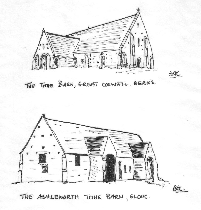
Looking at tithe barns in the possession of the National Trust we can get some idea of the size of these barns. The barn at Ashleworth in Gloucestershire is 125 feet long, and that of Great Coxwell in Berkshire 152 feet long. The former is 10 bays in length, whereas the later is only 5 bays! The largest tithe barn on record was 303 feet long. A small book published in 1938 concerning Tithe Barns [ S203] refers to various tithe barns in this locality which were still around then. Two of these, had been barns belonging at one time to St. Albans Abbey. One in the parish of St. Stephens at St. Julians Farm, and the other at Croxley Green. The former was built of brick and stone with a slate roof, though no mention was given of size, the latter at Croxley Green was 101 feet in length - consisting of 5 bays - and 38.5 feet wide. The external walls were flint with stone copings.
After doing various calculations based on the size of Ye Pightle, I concluded that Westwick's barn could at its longest been about 300 feet in length, but is more likely to have been about half that. We know the field in which it stood to have been 3 roods and 38 perches in size, i.e. 4477 square yards, or just under an acre. The Hare map of 1634 and the sketch map on the survey of 1696 as well as all the later maps on which it was shown, show the field to have been rectangular in shape, and approximately in the proportion of 3:1. If that was correct, the field would have been approximately 301 feet long by 134 feet deep. Assuming that the enclosed field was created after the barn was built, then the barn would have been in the centre of the field with enough space around it to manoeuvre wagons etc. It would not have filled the field entirely, but neither would it have been a small building rattling around in the centre. Whichever way you look at it, it would have been a substantial structure, probably between 80 and 130 feet in length, and a landmark easily visible from the Hemel Hempstead Road, or Berkhamsted Way as it was then called. It would also have been regarded as an important structure in the neighbourhood. The sketches below are of the Great Coxwell Tithe barn and Ashleworth tithe barn, both owned by the National Trust, and give some impression of how imposing such a building would have been.
[HRO's IA68, IL1, IL3, IL28, IL29, IL30, IL31, XI2, IM28-IM31, D/EV/P1; S96; S199]